What Is/Was Pipeclay And How Is It Formed?

Prospecting Australia

Help Support Prospecting Australia:

This site may earn a commission from merchant affiliate links, including eBay, Amazon, and others.
goldierocks said:
A bit like "indicator" and "reef". The first is any pyritic, quartzose or graphitic seam in slate (eg the "pecilmark" at Ballarat East - not an indicator of gold directly, just an indication of how many metres you are from the main quartz reefs - described by Mark Twain - see #9953 in Australian History). I find that most people dont realise that in the 1800s "reef" meant hard rock (eg sandstone, quartz). It confuses a lot of people in deep lead reports (another annoying term) because it is commonly referring there to a hard bed of sandstone or quartzite that they could not easily dig out wth a pick and shovel. So "struck a reef and followed it" often means different to what modern readers think!

Yeah a lot of these old terms only survive because, especially in places like Victoria where no substantial exploration took place for nearly 100 years, the only literature is OLD. Plus the newer geological papers are in 'modern geology speak' i.e. post-plate-tectonics. So there's a real dichotomy.

Somehow we need to the get "deep lead" replaced with something like "buried stream channel" or better yet "paleochannel" (a term us geologists actually use). The old timers kinda made it confusing by calling current stream channels as well as old buried channels "leads".
Shallow lead = Alluvial Gold
Deep lead = Paleochannel Gold
There, fixed!

As for indicators, these can be just curiosities really. They may be relevant to hard rock mining but little else. With modern detectors etc you're going over the entire area anyway. For us exploration geologists, well we'd take note of this anyway, particularly when understanding the structural setting of a deposit, but ultimately we're interested in the ore directly - and for that we have assays.

Yeah "reef" is really annoying hahaha. I have always just taken it to mean "hard rock gold occurrence" and then proceeded to investigate what the actual geology is. Luckily you do come across references to a "quartz reef" sometimes which is often an actual quartz blow. But then you get the problem of it being just quartz with no gold! Infuriating!
 
Moneybox said:
UnderEmployedGeo said:

Excellent illustrations UnderEmployedGeo and I love the colours but where is the gold? :playful:

If you find any of these around your area MB, you have a good chance of finding AU.
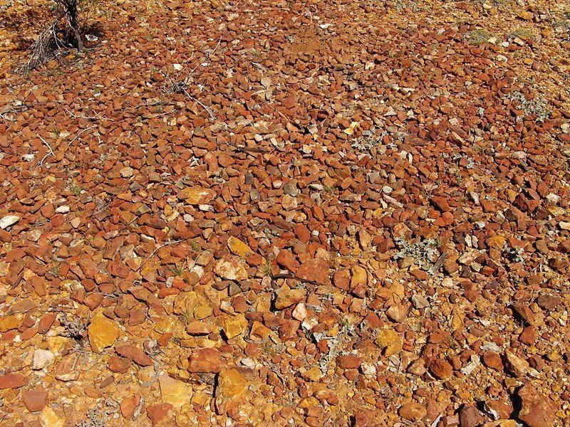
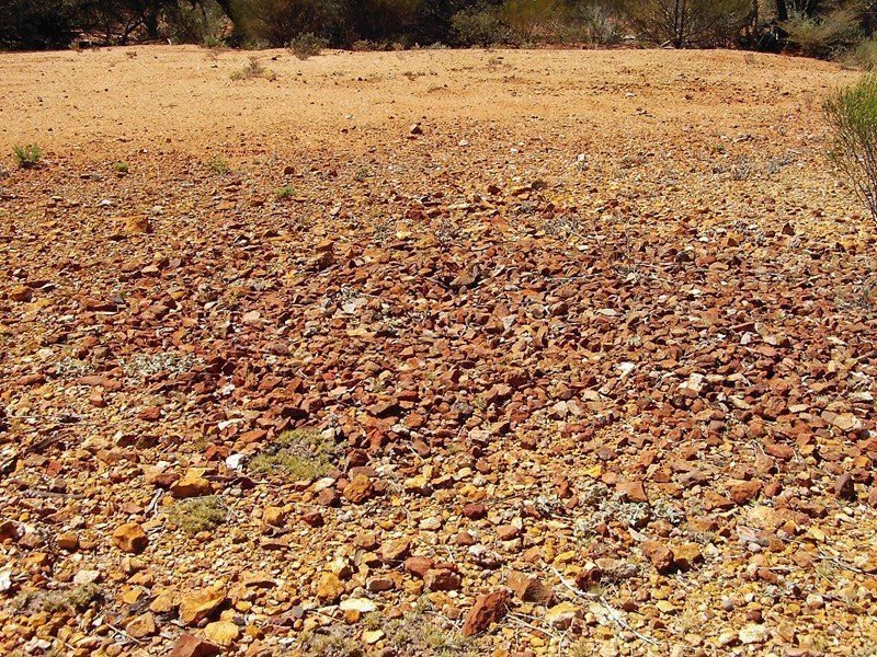
We named them "Volcano's" small low mounds that appear to have formed from a fissure. The rocks are unlike any surrounding them.

1642982329_volcano.jpg


1642982329_volcano2.jpg
 
UnderEmployedGeo said:
goldierocks said:
A bit like "indicator" and "reef". The first is any pyritic, quartzose or graphitic seam in slate (eg the "pecilmark" at Ballarat East - not an indicator of gold directly, just an indication of how many metres you are from the main quartz reefs - described by Mark Twain - see #9953 in Australian History). I find that most people dont realise that in the 1800s "reef" meant hard rock (eg sandstone, quartz). It confuses a lot of people in deep lead reports (another annoying term) because it is commonly referring there to a hard bed of sandstone or quartzite that they could not easily dig out wth a pick and shovel. So "struck a reef and followed it" often means different to what modern readers think!

Yeah a lot of these old terms only survive because, especially in places like Victoria where no substantial exploration took place for nearly 100 years, the only literature is OLD. Plus the newer geological papers are in 'modern geology speak' i.e. post-plate-tectonics. So there's a real dichotomy.

Somehow we need to the get "deep lead" replaced with something like "buried stream channel" or better yet "paleochannel" (a term us geologists actually use). The old timers kinda made it confusing by calling current stream channels as well as old buried channels "leads".
Shallow lead = Alluvial Gold
Deep lead = Paleochannel Gold
There, fixed!

As for indicators, these can be just curiosities really. They may be relevant to hard rock mining but little else. With modern detectors etc you're going over the entire area anyway. For us exploration geologists, well we'd take note of this anyway, particularly when understanding the structural setting of a deposit, but ultimately we're interested in the ore directly - and for that we have assays.

Yeah "reef" is really annoying hahaha. I have always just taken it to mean "hard rock gold occurrence" and then proceeded to investigate what the actual geology is. Luckily you do come across references to a "quartz reef" sometimes which is often an actual quartz blow. But then you get the problem of it being just quartz with no gold! Infuriating!

Unfortunately Victorian hydrogeologists still use the term deep lead for deep aquifers. And most Victorian shallow leads were also palaeochannels (A term I use for both - the distinction is about 30 m where a pause occurred while individuals had to raise money for equipment such as heavy pumps and become syndicates and companies). And of course reef was just hard rock (a quartz vein, a quartzite bed) and had no need for any gold-bearing connotation at all.
https://pubs.geoscienceworld.org/segdiscovery/issue/number/56
 
Would be great if one of our geos could throw some light on this mystery that has been with us since finding our first "volcano" back in the early 90's. Refer Post #22
The most unlikely looking ground in photo "2" gave up over an oz/AU outside the mound.
One we found at YouandMe resulted in a beautiful 5g.
Haven't kept a record but maybe 80% of surrounds around the mounds we have found have produced gold.

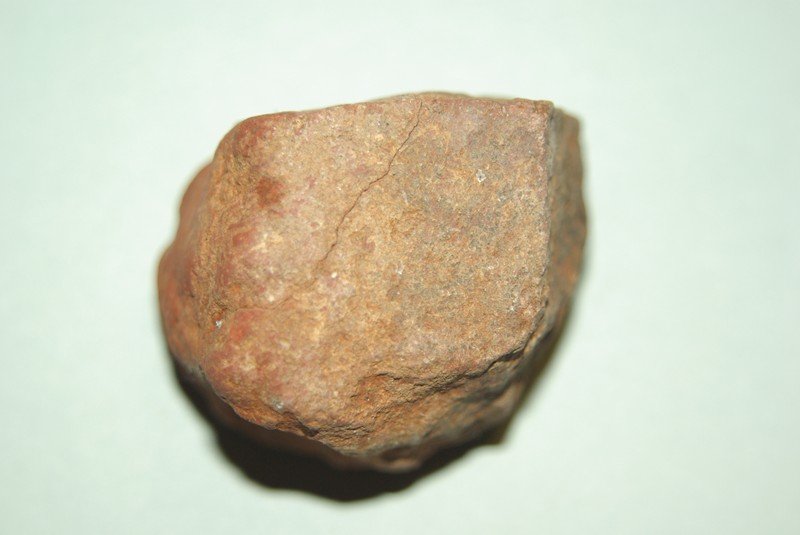
Close up photo of one of the rocks from the mound. Is not magnetic or give off a signal.

1643013403_volcano5.jpg


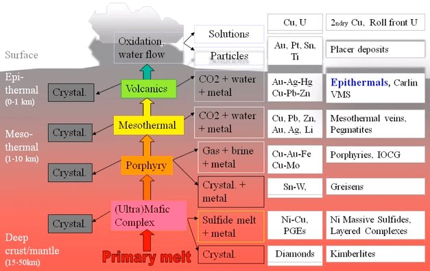
Website I found, could this have applied all those billions of years ago in our ancient goldfields?

https://www.911metallurgist.com/blog/epithermal-gold-deposits-characteristics

1643013623_epithermal.jpg
 
Nightjar. I've only ever found two similar mounds. Both were at Inglewood Vic. 1 to the north, and 1 to the west. About 4 metres round. Almost perfect circles, about 1.5 metres high. No humps or bumps on them. They are so smooth, they look manmade. There are no diggings anywhere near them, so It's not stockpiled wash. The consis tancy of the gravel is the same right through it. Very easy to dig as it was not compacted. Unlike yours, there was no gold on them, as I gridded them both. I spent hours detecting the areas around them, but got no gold. wiley.
 
Nightjar said:
Would be great if one of our geos could throw some light on this mystery that has been with us since finding our first "volcano" back in the early 90's. Refer Post #22
The most unlikely looking ground in photo "2" gave up over an oz/AU outside the mound.
One we found at YouandMe resulted in a beautiful 5g.
Haven't kept a record but maybe 80% of surrounds around the mounds we have found have produced gold.

Close up photo of one of the rocks from the mound. Is not magnetic or give off a signal.

https://www.prospectingaustralia.com/forum/img/member-images/1414/1643013403_volcano5.jpg

Website I found, could this have applied all those billions of years ago in our ancient goldfields?

https://www.911metallurgist.com/blog/epithermal-gold-deposits-characteristics

https://www.prospectingaustralia.com/forum/img/member-images/1414/1643013623_epithermal.jpg

Is there a way to search post by number?
 
wiley coyote said:
Nightjar. I've only ever found two similar mounds. Both were at Inglewood Vic. 1 to the north, and 1 to the west. About 4 metres round. Almost perfect circles, about 1.5 metres high. No humps or bumps on them. They are so smooth, they look manmade. There are no diggings anywhere near them, so It's not stockpiled wash. The consis tancy of the gravel is the same right through it. Very easy to dig as it was not compacted. Unlike yours, there was no gold on them, as I gridded them both. I spent hours detecting the areas around them, but got no gold. wiley.

Possibly very old malleefowl nest mounds. Look for tiny fragments of broken eggshell if you come across anything similar again.
 
Nightjar said:
GS,
Definitely not Mallee Fowl, we have also found their mounds totally different.

My comment above specifically addressed wiley coyote's finds in Inglewood, Victoria, which sound similar to some malleefowl mounds that I've seen in WA. I agree that your WA "volcanoes" are nothing like malleefowl mounds.
 
Nightjar said:
WC
Have never found gold in the the mounds which are barely above level of surrounding ground. Gold only around the outskirts.

GS,
Definitely not Mallee Fowl, we have also found their mounds totally different.

MB,
Post #22 is in this thread, scroll back, number is in top RH corner.

Thanks Peter, that looks familiar but I've not noticed these patches as a mound but next time I'll take a closer look. I know where there's a small patch of this rock and we extracted a lot of small nuggets just down the slope from it. This area had a lot of small non magnetic light weight hot rocks that looked like these as well.
 
Yes MB, Some of the volcanoes are slightly risen mounds and sometimes have an indent in the centre which we determined to be possible fissures?
Over the past 25 years from when we first discovered have quizzed numerous geos in the area, sent off a query to the WA Curtin University. The most common answer was, "Pebble Mice" Impossible, they would never be able to move some of the rocks, and the same rocks extend down at least 1 metre. (That is when we stopped excavating)
This thread began with pipeclay question and can relate that one of the mounds was situated approx 20 metres away from a creek from which we dug nuggets buried in the Kaolin type clay in the creek bed.
Hoping you can come across a few more in your area that are gold producing? :perfect: :goldnugget:
 
Re #22: looks like the surface expression of a structure that is eroding differently to surrounding material,
maybe more brittle, less affected by chemical weathering. That would explain coarser texture.
Iron rich judging by the reddish colour. Why not just a gold hosting quartz/iron rich vein or pod?
It's very common for veins of quartz (for example) to be expressed at the surface as a concentration of scattered pieces of broken quartz,
as normal erosion processes tend to break up and separate exposed quartz veins. The same would be true of any harder, brittler and
less soluble rock or mineral masses.
 
Nightjar said:
Yes MB, Some of the volcanoes are slightly risen mounds and sometimes have an indent in the centre which we determined to be possible fissures?
Over the past 25 years from when we first discovered have quizzed numerous geos in the area, sent off a query to the WA Curtin University. The most common answer was, "Pebble Mice" Impossible, they would never be able to move some of the rocks, and the same rocks extend down at least 1 metre. (That is when we stopped excavating)
This thread began with pipeclay question and can relate that one of the mounds was situated approx 20 metres away from a creek from which we dug nuggets buried in the Kaolin type clay in the creek bed.
Hoping you can come across a few more in your area that are gold producing? :perfect: :goldnugget:

If I come across one on one of my leases I'll investigate with the excavator (that's after testing the surrounds with the metal detector) :lol:
 
Not a mallee fowl nest. No egg shell bits, no holes, no metal, so not man made. No detector holes anywhere near the second one, as It was in a very isolated spot. I got a 2oz bit and about 6 smaller bits about a kilometre away. wiley
 
Nightjar said:
Nightjar said:
We named them "Volcano's" small low mounds that appear to have formed from a fissure. The rocks are unlike any surrounding them.

https://www.prospectingaustralia.com/forum/img/member-images/1414/1642982329_volcano.jpg
https://www.prospectingaustralia.com/forum/img/member-images/1414/1642982329_volcano2.jpg

Do any of our resident geo's have any explanation for the these anomalies?

You previously posted about "mini volcanoes" here:
https://www.prospectingaustralia.com/forum/viewtopic.php?pid=589243#p589243

In answer, goldierocks gave his opinion here:
https://www.prospectingaustralia.com/forum/viewtopic.php?pid=615419#p615419
 
There are all sorts of features that can form where groundwater discharges, and I have seen a number of mounds formed in this way by cold water. Usually they are mounds of clay prills, or small clay domes, but some become large like these features in Azerbadjan (note some things here are url links, others images)

https://www.bing.com/videos/search?...adjan&qpvt=mud+volcanoes+azerbadjan&FORM=VDRE

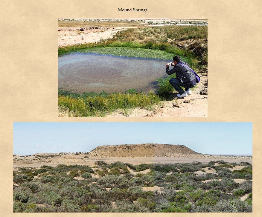
Sometimes they form mound springs, as north of Maree, where they occasionally build up an elevated mound.

1643848522_mound_springs.jpg


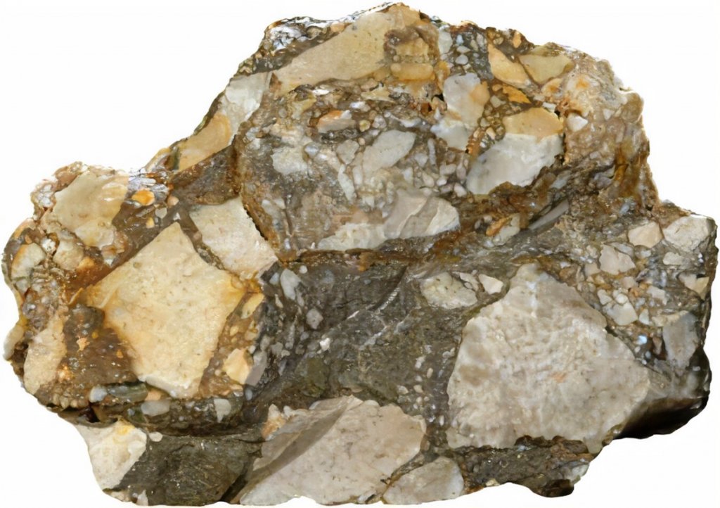
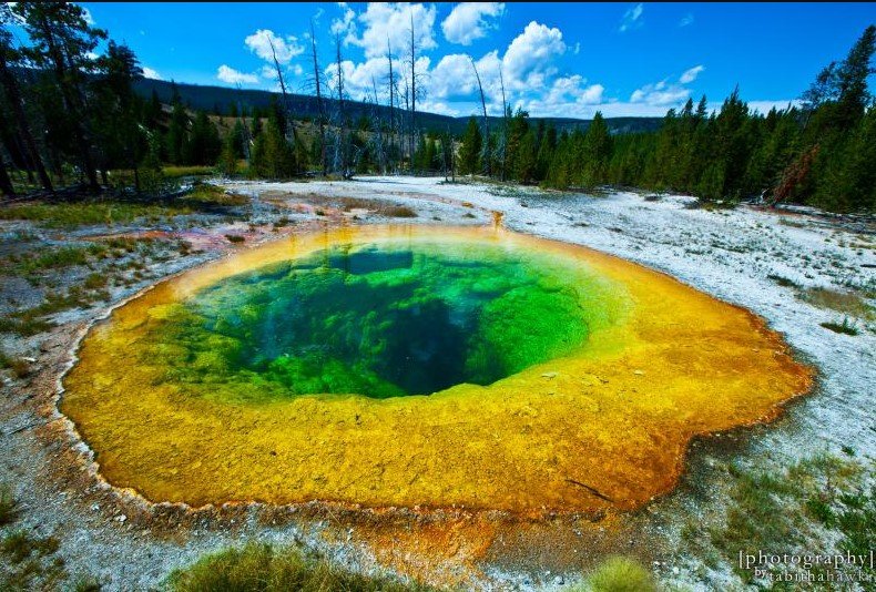
And of course some are formed by hot water, sometimes explosively, in volcanic areas

1643850242_hot_spring_breccia.jpg

https://www.bing.com/images/search?...AE7AD9&selectedIndex=98&ajaxhist=0&ajaxserp=0

1643850973_hot_spring.jpg


The last can consist of broken rock fragments but ALWAYS contain some chemically-deposited cement (silica or calcite, sulphur, less common types of clays, sulphide minerals, barite) which yours lack - for this and other reasons I confidently exclude such epithermal mounds - including a lack of nuggets near surface, geological improbability in your area).

The first two types are mud, or mud pellets, so differ from yours which are clearly fractured bedrock fragments and which lack any fine grained mud. It is possible that yours could be related to groundwater discharge (eg at higher than normal pressure along a fault zone, sufficient to fragment rock and move the fragments around), but I am rather doubtful of that (still far more probable than epithermal).

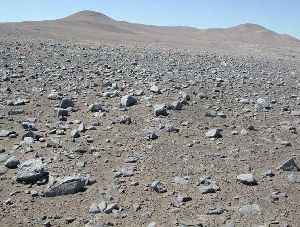
My suspicion is that you are looking at the last residual remnants of a horizontal weathered surface (i.e. basically a weathered soil, such as a desert lithosol) where everything around it has been weathered away. Many of us are familiar with the lateritic soils of Australia, but these were formed during high rainfall periods in what are now deserts, not in deserts of the time. The lithosoil (i.e. means rock soil) soils that are forming today (last millions of years) in our desert areas are quite different, and usually consist of rock fragments because there is not enough rain to form clays. These can form flat layers, and if streams cut down into them over time (or just sheetwash) they can be removed, but more resistant patches may remain as flattish residual mounds.

1643850503_desert_lithosol.jpg


That does not explain any gold association. Firstly, is it a statistically significant association of gold and mounds (are we talking dozens of nuggets)? If so, is it because you are attracted to the mounds so concentrate on those areas? And lastly, mineralized rock can form more iron rich areas of lithosols when it weathers and these can be more resistant to erosion, so are the last remnants to be removed, leaving flattish mounds.

Hope that helps.
 

Latest posts

Top