Did Goldfield X Produce Detectable Gold? What Is A "Goldfield"?

Prospecting Australia

Help Support Prospecting Australia:

This site may earn a commission from merchant affiliate links, including eBay, Amazon, and others.
Joined
Jul 28, 2020
Messages
85
Reaction score
121
It's one thing to read up on the historical production of goldfields and see how much gold they produced overall, but it's trickier to determine if the gold produced was of a detectable size (and depth).

GeoVic (and the data sources it employs) have a lot of information about mines and deposits - reef or placer, production, dates, etc - but it doesn't tell me if there is any use in swinging a detector in the area.

Are there any resources for this kind of information? Maybe gold mining (history) books? I'm willing and able to connect the dots if there are only, let's say, indirect bits of information...

And while I'm at it, what is the definition of a goldfield? In GeoVic and Geological Survey datasets we can see the areas outlined, but what does this really mean?

I'm looking at the geophysical interpretations datasets, fault lines, production centres, elevation contours, watercourses and other things but there is no clear relationship that could lead me to infer the exact extent of a goldfield. Also, many successful mines and workings are not within the bounds of a "goldfield" as such.

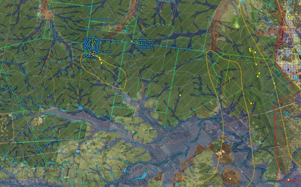
For example, Yankee Creek is a small, minor goldfield east of Bendigo. There are a few mines running NW/SE at the north end of the goldfield and just beyond it, roughly parallel to a faultline. Somebody was interested in the area just north of the goldfield as evidenced by a swath of chemical surveys (probably done by Fosterville) just north of the goldfield. Appreciable gold (more than normal background level) was found in a few of those samples, on and over a hill outside of the goldfield area itself.
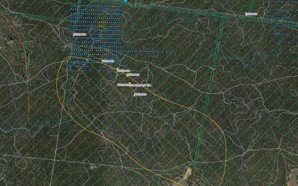
1618045385_screen_shot_2021-04-10_at_18.59.21.jpg


So what exactly is a "goldfield"? Clearly, gold is found outside of "goldfields". What defines a goldfield's boundaries?
 
Evening B in B.

I'm sorry but I'm not able to help with a definitive 'what is a goldfield' answer. I thought it would have just been where they have found a 'significant' amount of gold. More so than just a larger than normal background reading. But no idea really.

As far as what they were finding the old mining reports and newspaper reports found on Trove can give some decent clues.

And Geovic and the different Google Earth overlays that you can get generally show placer or vein hosted. Generally shallow leads or the throw out piles of deep leads might be worth a try with the detector. Vein hosted - I tend to look at the depth of the workings. If they were working 100 + feet I tend to think that it is less likely to be worthwhile with a detector. But there would be definite occasions where that assumption would be proved wrong.

I have a question for you though. Those blue/yellow/green dots on your screen pic above - how did you get those there? I've tried to find drill data but can't. Is the data you show freely available somewhere? Is that a file you've over-layed on Google Earth or is it on GeoVic and you've then chosen the 'Show area on Google' option or whatever it is called?

Thanks, N.E.
 
hey NE,

Ahh Trove looks to be very useful, thanks! Didn't know about this.

The screenshot is from my QGIS prospecting file. QGIS is a free, open-source geographic information system application (like ArcGIS). You can do all sorts of amazing mapping things with it.

In the screenshot, you can see a google earth background with a few overlays: elevation contours, land status (the light green diagonal lines, indicating state forest), the goldfield (gold blob with diagonal lines), linear geological structures (light purple lines - faults, contacts, etc), ancient streams (orange dashed lines), watercourses (light blue line), production centres (the triangles, yellow upside down indicates a primary/reef mine), and geochemical surveys (the colored dots). There is a lot more in the project.

This information is all available from the Victorian Spatial Datamart:
https://services.land.vic.gov.au/SpatialDatamart/

You can also download large bundles of datasets from the Earth Resources site:
http://earthresources.efirst.com.au/default.asp

I often explore datasets on this site, which also links you to downloads:
https://www.data.vic.gov.au/

The geochemical survey data is here:
https://discover.data.vic.gov.au/da...rces-spatial-data-collection-for-the-datamart

I don't know if you can get it on GeoVic, though.

I have put a very significant amount of time into setting this up. It is far more comprehensive and user-friendly than GeoVic, but QGIS requires a lot of technical knowledge (or dedication, in my case) to set this up. I've imported, massaged, and styled all the data into something functional. Another huge benefit is that the data is all offline.

Here's a wider view of that first screenshot, with some geological overlays:
1618049355_screen_shot_2021-04-10_at_20.05.04.jpg


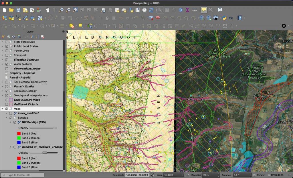
And here's a view of some of Eaglehawk/Whipstick, with an old map overlaid:
1618049425_screen_shot_2021-04-10_at_20.08.12.jpg


I'm a novice detector, wanna-be-prospector, so this may be worth more to somebody else, but I'm working towards making it worth more for me - that is, finding gold with it :)
 
Thank you for the detailed reply B in B. Great info and gives me a few more tools in the toolbox. Now I've just got to work out how to use it. :lol:

Some of the stuff in Trove is great. Some of the newspaper/mining correspondent reports are mind blowing in the amounts of gold they were getting.

Thanks again :Y:
 
NE:

no worries :D enjoy

I learned about QGIS ages ago but didn't think to apply it to prospecting until I saw this post by a tryhard1968, then went a full tilt onto setting up my own file: https://www.prospectingaustralia.com/forum/viewtopic.php?id=34981

great intro, and there are bajillions of generic QGIS videos on youtube. it's what a lot of the geoscience people in govt agencies use for their mapping - you know, the people who put together the data for geovic and geovic itself.

just reading Trove now, they really put a lot of detail in the newspapers back then about the ongoing work. and yeah, incredible quantities... jeez! already helped me to sort out some priorities for different areas with whether or not nuggetty gold was present, and the depths of the shafts as you noted. thanks again

Aussiefarmer:

That's what I'm seeing down in Vic, I suppose the only relevant takeaway is that a "goldfield" is just a rough indicator of past mining activity or research, and in no way means there isn't gold outside its borders.
 
The other question that immediately comes to mind is; What do we now class as detectable gold?

That adds a whole new goalpost to previous decades of detecting on the old (possible extensions) and more recent goldfields. Some of the gold and speccie pieces found with detectors now are minute.

I remember hearing a story (possibly on here somewhere?) of an old timer mentioning something along the lines of very rich goldfields being now out of reach or erased as the indicators have been somewhat removed via detectors over the years.

Trove is certainly a wonderful place to dig into at times.
Cheers,
Shauno.
 
Jaros said:
Looks like it's "Go West young man, Go East young man, Go South young man" go to the beaches, but then again they will probably be next on the list. :mad:
I'm not far from a beach occurrence, I will get around to sampling it one day :cool:
 
Syndyne said:
The other question that immediately comes to mind is; What do we now class as detectable gold?

That adds a whole new goalpost to previous decades of detecting on the old (possible extensions) and more recent goldfields. Some of the gold and speccie pieces found with detectors now are minute.

I remember hearing a story (possibly on here somewhere?) of an old timer mentioning something along the lines of very rich goldfields being now out of reach or erased as the indicators have been somewhat removed via detectors over the years.

Trove is certainly a wonderful place to dig into at times.
Cheers,
Shauno.
Very interesting point, to think..
If everyone shared their pinned ground and it was all put together on one map, how interesting would that look..
 
I'll collect it if you want....don't worry, your secret spot is safe with me!!!! It's certainly a good point though, getting harder and harder to follow the patterns with so many pieces of the puzzle missing.
 
It seems that today, researching where gold occurred in the past is far less a useful endeavor than in it was yesteryear. I mean, for significant finds. There will always (?) be little bits in a given area, but untouched and accessible ground is rare. More useful is to understand the geology of gold and follow that.

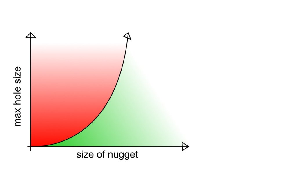
I'll define "detectable":

A nugget that...

1) my detector can see

and

2) is of a size and depth that puts it in the green zone of this graph:

1618134926_nuggget_to_hole.jpg


If a nugget is too small, I'm only willing to put in a certain amount of energy into digging the hole and, very importantly, isolating it from the dug-out soil.

There are more variables to this, such as ground hardness, how broke I am, if it is raining or not, how badly I have to pee, how many pieces of junk and I've dug in the recent past, etc. But this graph conveys the general idea.
 
To answer the question "What is a Capital G "Goldfield" that is marked on maps with a boundary, often rectangular or following a ground feature ( river, ridge etc)? ...... These are defined areas in which specific parts of the States Mining Acts apply/applied.

The way it went was that the Mining Act applies to the State generally, then when someone announced a gold find then a DoM Inspector/Warden inspected the area & based on the geology, likely extent of the field & number of diggers making wages declared it a "Goldfield". That proclamation then caused a number of things to change including the rules under which leases were issued & also the finder got a reward - $$ or a larger lease than other miners, or both.

eg From QLD Mining Act 1898 :
"Goldfield"-Any portion of Crown land proclaimed or constituted, or deemed to have been proclaimed or constituted, a
goldfield under the provisions of this Act;


Provisional Goldfield.
Whenever the discovery of payable gold on Crown lands is reported in
writing under the hand of and signed by the person claiming to have
made such discovery (or, if such person is unable to write, by a writing
attested by a justice of the peace or warden) to the warden whose office
is nearest the situation of such discovery, the notification of such discovery
by such warden, posted outside his office, shall operate to proclaim the
portion or portions of Crown lands to be a goldfield within the meaning
and for the purposes of this Act, which shall be contained in a square
the boundary lines of which shall be directed to the cardinal points, and
the central point in each boundary line whereof shall be distant ha1-a-
mile from such place of discovery, and such notification as aforesaid
shall have the effect of a provisional Proclamation of the said area as a
goldfield, to be in force until the same is revoked or cancelled, or any
enlarged or diminished area shall be proclaimed under the provisions of
this Act


Reward for the discoverers of goldfields. .
It shall be lawful for the Governor to cause to be paid a sum of money,
not exceeding twenty thousand dollars, to the actual discoverers of any
new goldfield, such sum to be paid under the terms and conditions to be
prescribed by the Regulations. (Decimal currency reference substituted pursuant to section 7 of Decimal
Currency Act of 1965.)"

So any proclaimed Goldfield boundaries mean only that somewhere inside them that a fair bit of gold was found, they definitely dont mean that everywhere within the boundary contains gold, nor does it say anything at all about the ground outside the boundary.

Hope that helps
 
Gday broke go to the whipstick forest its your back yard its huge with lots of gold bearing areas it start prospecting but when you do be prepared to find nothing but junk make yourself a map of where you have been then keep trying as at some stage you will hit a good spot I know we keep going back to spots that have rewarded us but usually thats due to how much time we have theres still plenty out there you just have to find it if you are searching for new ground be prepared to find nothing cheers muk
 
"It's one thing to read up on the historical production of goldfields and see how much gold they produced overall, but it's trickier to determine if the gold produced was of a detectable size (and depth)."

Any Goldfield will have registered mines on it. If you can determine the age of the mines then that helps as far as depth goes in that any mine registered before WW2 almost certainly was found by surface sampling as exploratory drilling for gold based on geomag anomalies etc wasnt widespread until 1950s & beyond. Even when loaming the early diggers didnt generally dig beyond 2ft whilst prospecting new areas as it is a mugs game digging deep holes on spec.

Once they found gold at the surface level then sure they would go down until they found the source / bedrock but the point is that they found gold at the surface first. Anywhere there was alluvial gold is worth a shot but dont ignore reef based mines. It might have been a reef surface outcrop that hadnt shed yet and the surrounds are barren or it might have shed hundreds of meters in which case some might still be there for the taking.

Of course once one surface find had been chased underground and a reef found then other miners would sink shafts without any surface tell, just hoping to intersect it outside the original miners lease. But even so there had to be an initial surface find to kick off all that digging so look for the oldest mine in a cluster.

As far as whether the gold size was big enough to be metal detectable that is trickier. Trove is your best source, you want to look at the first few years of news on a given goldfield as even if it was originally alluvial/elluvial later on it may well have moved to underground reef mining.

Giveaway names like Nuggety Gully also help:)
 
That's great info XLOOX, thank you!

Muk, I've done a lot of trash-cleanup at Whipstick, yeah huge area. But also very well-trodden. I'm more interested in areas where detectors haven't been en masse.
 
BrokeInBendigo said:
That's great info XLOOX, thank you!

Muk, I've done a lot of trash-cleanup at Whipstick, yeah huge area. But also very well-trodden. I'm more interested in areas where detectors haven't been en masse.

A difficult thing to come across in Victoria, but not completely impossible. WA is your best bet....
 
I realise this is old but XLOOX has it right. We came across this problem when trying to estimate the gold production of each goldfield in a State. We found that the "declared" boundaries often had no clear relationship to the geological distribution of gold. Named goldfields could have recorded tens of million ounces of gold production or a few hundred ounces - you could fit half a dozen of some goldfields into the boundaries of another. Sometimes the entire production was within a single sq km, other times many tens of sq km.

I mention this because if you are trying to work out where best to detect, you need to realize that the old "political" boundaries like this are not very helpful. You can do better by simply overlaying old shafts and leads using the states' digital database, overlaying geology and working out which leads are buried under basalt lows fetc - then overlaying "no go" areas for prospecting. And deciding whether you are going to cover everything or just old mine dumps- in the latter case you can extend further over buried leads (placers). Then talk to farmers because in places like Victoria most will be on private land (certainly not all).
Great Minds .....
https://www.prospectingaustralia.com/threads/what-to-look-for.34584/post-561603
 

Latest posts

Top