Where are the alluvial gold bonanzas of the past?

Prospecting Australia

Help Support Prospecting Australia:

This site may earn a commission from merchant affiliate links, including eBay, Amazon, and others.
A few questions here.....

1. Have a higher chance of success (not quite the same as wasting time)
2. Most may have been palaeoplacer in the past, but for the reasons you state most that is AVAILABLE to you now is in modern rivers or near exposed and uplifted older river gravels. Not only is digging a shaft hard work, but in wet ground it was extremely dangerous with up to a death per day on some goldfields. Also, almost the entire Victorian forestry industry up to 1900s was devoted to timber for mines and to a lesser extents ports - they did not know how to season hardwood so it was not a choice for housing. Try chopping down that many trees now to provide the close timbering required in underground alluvial mines and see how you go (you'll be drawn and quartered)- there are alternatives to timber but not cheap because you are basically trying to keep wet sand and mud from burying you. And you will have to pump in most cases.....
3. Detecting is definitely the more fun way to go as a hobby and you can get gold shed from uplifted alluvials or from reefs being eroded away at surface (in the adjacent soil) as well
4. You can fairly easily prospect uplifted gravels shown on geological maps - not a lot to learn. The gravels containing the gold will usually be identified as Tertiary (particularly Older Tertiary) or Palaeogene. And they will usually be called fluvial or river gravels (many other gravel types lack gold). You need to prospect in the soil near what would have been the base of the gravels when they formed (where they lie on older bedrock). Not just everywhere where they lie on bedrock, but preferably the lowest former base, that would have been the active stream channel. Obviously old workings in the gravels that are shown on the maps are a clue to where to look. Needs a bit oif learning but not a lot. Uplifted gravels also have the advantage that the old-timers often lacked water (they would sometime stockpile for up to 3 years waiting for rain), so they could be very inefficient in getting all the gold in such cases. Mones weres till working such gravels in the 1980s (eg near Avoca in Victoria)

Hope that helps.

..."4. You can fairly easily prospect uplifted gravels shown on geological maps - not a lot to learn. The gravels containing the gold will usually be identified as Tertiary (particularly Older Tertiary) or Palaeogene. And they will usually be called fluvial or river gravels (many other gravel types lack gold). You need to prospect in the soil near what would have been the base of the gravels when they formed (where they lie on older bedrock). Not just everywhere where they lie on bedrock, but preferably the lowest former base, that would have been the active stream channel."...

..."You need to prospect in the soil near what would have been the base of the gravels when they formed (where they lie on older bedrock). Not just everywhere where they lie on bedrock, but preferably the lowest former base, that would have been the active stream channel."...

goldierocks how does one work this out? Is it possible from a geological map? Can you find the base of the gravels off modern topography?
By looking at the age symbols on a geological map as I described above.

As for finding the base - the base of WHICH gravels? The simple answer is that you can if they are "uplifted" as I mentioned, or very shallow gravels resting on bedrock on the hills. The base is where the gravels contact older bedrock.

As I said "identified as Tertiary (particularly Older Tertiary) or Palaeogene. And they will usually be called fluvial or river gravels" And they will rest on Paleozoic bedrock not on older gravels, clays etc.

The other clue is the gravels should have a high proportion (or be dominated by) pebbles and cobbles of white vein quartz pebbles, not by fresh bedrock (sandstone etc). There is theoretically a reason why this is important.
 
Last edited:
When you see rounded pebbles in the ground, it tells of an eroding elevated river bed in the vicinity. Whilst all old river courses do not contain gold, they are worth checking for.
Sometimes the old river bed is completely eroded away but the pebbles can persist. Seeing just a few can be a clue.
Also if you can get some idea of the course of an old river course, check adjacent hills or ground that the old river course may have once traversed.
Hawkear, although I agree it is mostly simpler than that in Victoria, in that old maps contain the information for most areas.
The nature of the pebbles is important. Victoria seems to have undergone a period of deep weathering in the Palaeogene, so that rock was reduced to white clay and washed to the sea in large rivers. The gravels from those rivers (White Hills Gravel) are one good source of gold, although tending to be as finer gold rather than nuggets (just an empirical observation). However the plains and very low hills were still blanketed with the things that could not be reduced to clay - vein (reef) quartz and gold (this was partly a blanket of "lateritic" clay such as is now common in WA). So quartz, clay and gold not rock fragments like sandstone and slate because they had been reduced to clay and sand by weathering.

Then Victoria was uplifted and deep valleys were incised into the plain by vigorous rivers incising themselves into fresh rock. The vein quartz fragments and gold were washed into those deep valleys to form gravel and conglomerate dominated by white quartz eroded off the plains, not fresh rock fragments (i.e. much like the earlier White Hills Gravel that now remained on hilltops). The clay and sand washed away down the rivers. to the sea. These quartz gravels - which sit directly on fresh bedrock of the valley floor - were the major producers of alluvial gold. Presumably because original fresh rocks had been converted to clay and sand and washed to the sea, leaving quartz pebbles and gold behind (i.e. therefore gold was very concentrated relative to the rock that it had originally occurred in).

Gradually the uplifted plains (now a plateau) were washed clean of their deeply-weathered veneer, and fresh bedrock gradually became exposed. This bedrock fed cobbles and pebbles more of sandstone and fresh rock - the ratio of vein quartz and gold to fresh rock was now more like it occurred in its source bedrock, and these placers tended to be less lucrative. Also these gravels tended to overlie earlier gravels in the valleys, not bedrock. With time the valleys became clogged with clays etc and rivers were less vigorous (and also less able to mechanically concentrate gold). These late rivers were only locally important economically
but tended to be large volume and very low grade deposits where worked (eg around places like Omeo).
 
I thought that since people liked my initial posts here, I would give you a bit more, as it may help your prospecting.

People panning in modern streams often don't understand that probably most Victorian alluvial gold did not come from gravels in flowing water, but in the same streams in gravels metres to hundreds of metres below what was the level of flowing streams when the miners arrived. That is one reason why gold was often only first discovered after a few people had frequented a goldfield area for some time (e.g. shepherds).

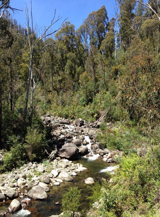
Here is a typical Victorian stream in hillier country. You can see that there is a rather limited volume of gravel in it, the stream typically flowing over hard bedrock. It could all be turned over by a couple of miners at a rate of tens of metres of stream per week, over a width of 10 m if you are lucky in many cases, from gravels that vary from 1 or max 2 metres deep, to more typically tens of centimetres deep confined between areas of outcropping bedrock. It could be very rich, but there was often little gravel volume, so total gold production was not huge unless you got a good patch, and the miners soon worked it out. Most people panning in streams are panning the recycled leftovers of worked gravel, biut if they dig out crevices in the floor of the stream they get a bit of gold missed by the old-timers..

1610087870_alluvial_minus_1.jpg


The reality is different in terms of where much alluvial gold came from (palaeoplacers). Alluvial production was from active stream systems (possibly a subordinate part of the total production), and on adjacent flats where buried river gravels were mined to depths of 30 m. It is difficult to determine how much of the shallow placer gold production of the Western Uplands was mined from Pliocene and younger sediments, relative to that produced from underlying, older but shallow, palaeoplacers. Much was probably recycled from gravel deposited at an earlier time, e.g. in the headwaters of Loddon River Group drainages. Older gravels of this type appear to have been mined from beneath younger colluvial deposits in the shallower alluvial gold workings of many goldfields (e.g. Ballarat).

Look at this gully. The water level was probably nearly 2 m higher than the base of the valley now, a bit swampy and ill-defined - allowing for 150 years of crap washing in, the gravels they were mining were probably below the present base of this gully, perhaps a metre or so (so 2-3 m below the water. Although in the same valley, and followed by a modern gully, the original gully and gold-rich gravels probably formed millions of years earlier.

1610088072_alluvial1.jpg


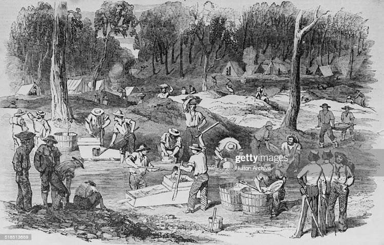
Now look at this drawing done in goldfield times, and see the low mine dumps behind the opposite side of the gully.

These dumps were from shallow shafts, perhaps a few metres to ten metres deep, from which the miners were extracting gold-bearing gravel millions to probably often 15-30 million years old. Again, in the same valley, but offset from the modern flowing stream. Younger streams have successively moved back and forward sideways in the valley, covering these early gravels with clay and sand, and themselves have some gravel in them, but only a small volume. The ancient gravels were up to 50 metres wide in places (bigger rivers) and a good continuous layer of gravel in them 0.5 to 1 m thick was taken up the shafts. What they are doing in the picture is washing the gravel that they brought up the shafts in the modern flowing stream, often not working the modern stream itself, and all the waste crap they were bringing up was ending up in the modern stream. So when you pan the flowing stream now you are often panning a stream that never had much gold in it to start with, but which contains lots of gravel brought up the shafts (from which the gold had already been extracted). The miners would say they were working a "shallow lead" from their shafts.

1610088627_alluvial2.jpg


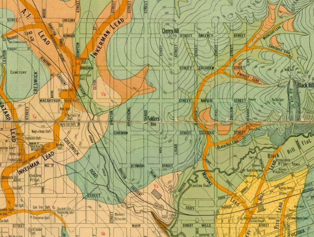
You can see from this map of the Ballarat goldfield how the gold leads such as the Inkerman and Mopoke do not follow even the modern valleys (the Mopoke Lead cuts across modern Yarrowee Creek at right-angles in the bottom-right of the map.

1610090363_ballarat_leads.jpg


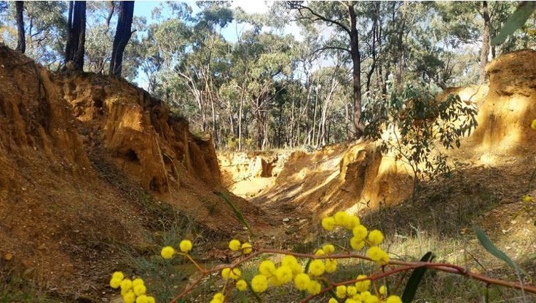
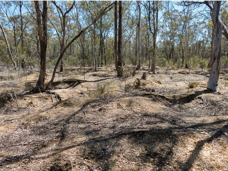
After they finished (and 150 years) their shallow shafts now look like this.

1610088803_alluvial3.jpg


You will commonly see these low mounds off to one side of the modern flowing stream, metres to tens of metres off to the side of it. The detectorologists often do better detecting these mounds (because the old miners mistakenly dumped some good gravel beside the shaft that they had brought up), than do the panners who now try working the stream.

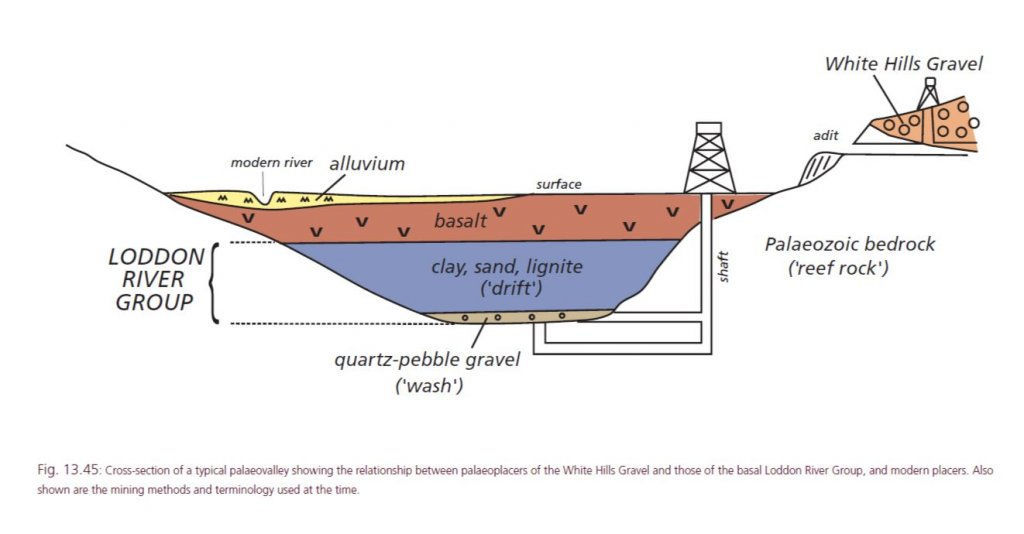
Variations on the theme is that earthquakes have sometimes uplifted the old gravels, so that they are now on hillsides or hilltops above the modern streams (see White Hills Gravel in section). Another is that the old miners had limited resources and machinery, so usually only followed buried river gravels until they got more than 30 m below surface. Then goldfields went quiet and they moved on, later companies and syndicates moved in with good pumps and started to continue mining the gravels to greater depths (more than 150 m at Ballarat West). These were called "deep leads" (see bottom of palaeovalley in section).

1610089935_deep_lead_section.jpg


Hope that helps.
I just found this photo that emphasizes my point that most of the gold came from paleoplacers rather than from in modern streams. This is the 1851 gold discovery site at Ballarat. You can see how the alluvial gold workings are higher than the creek level and only on one side.

1679899155017.png
 
30 ounces for the afternoon wash, only if. Most today would be lucky to wash an ounce from 30 afternoon's 😅 me included.
 

Latest posts

Top