National High Resolution Mapping

Prospecting Australia

Help Support Prospecting Australia:

This site may earn a commission from merchant affiliate links, including eBay, Amazon, and others.
Awesome resolution in 2d only on my ipad!
Where can I find something like this that Is Apple compatable ?
Gcause mentioned MemoryMap. Any experience with this?
 
Ryan27 said:
Awesome resolution in 2d only on my ipad!
Where can I find something like this that Is Apple compatable ?
Gcause mentioned MemoryMap. Any experience with this?

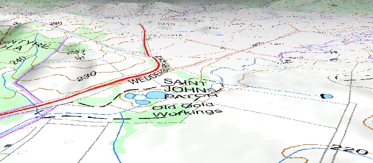
I use memory map. excellent 3d mapping tool and great coverage.i have the Vic 1:25,000 series.

example 3d

1404898560_asaa.png
 
Thanks loamer
I'll give memory map a go. I don't get a lot of time to learn technical stuff. So I want to be on the right path to start with.
Love my iPhone and love my ipad, it has made my life a whole lot easier with work, managing slippery builders with facts and photos!
Cheers Ryan
 
there will apparently be quite a few developments in mapping this year so i wont rush in to changing devices too much until it all settles in

currently google earth maps can be up to 6 - 10 year old images and low resolution

Whats coming is maps that are all less than 3 months old and high resolution too

data from mining departments around the country will become cross platform compatible

fingers crossed they provide whats on my shopping list such as GPS active maps so you can walk out in the field and see exactly where you are in relation to the border of leases , national parks or reserves , show the boundaries of crown land / private land and have accuracy of 3 - 5 metres , plus navigate your way to geological features and mineral locations.

Oh , and if you didnt notice yet , that national mapping page will have the ability to import data sets and probably the option of adding data layers so you can click on a spot and get historical data such as who operated a mine , how much gold was found , links to old newspaper articles and drill results ..... the possibilities are endless.
 
HeadsUp said:
there will apparently be quite a few developments in mapping this year so i wont rush in to changing devices too much until it all settles in

currently google earth maps can be up to 6 - 10 year old images and low resolution

Whats coming is maps that are all less than 3 months old and high resolution too

data from mining departments around the country will become cross platform compatible

fingers crossed they provide whats on my shopping list such as GPS active maps so you can walk out in the field and see exactly where you are in relation to the border of leases , national parks or reserves , show the boundaries of crown land / private land and have accuracy of 3 - 5 metres , plus navigate your way to geological features and mineral locations.

Oh , and if you didnt notice yet , that national mapping page will have the ability to import data sets and probably the option of adding data layers so you can click on a spot and get historical data such as who operated a mine , how much gold was found , links to old newspaper articles and drill results ..... the possibilities are endless.

Mapping is really in its infancy. I've been avoiding buying a independant GPS for this reason. Our phones will be linked to our detectors one day. Did I just say that? Mmmm maybe Mine lab could incorporate apps that would change settings automatically due to ground conditions and whilst giving you a birds eye view of the ground you are covering to ensure you are working an area thoroughly. To top it off the why not the phone/detector talk to each other to alert of any changes in threshold that may be too slight for the human ear to hear?
Food for thought...
 
Hey HeadsUp

Great share, thanks!!

I just got a GeoVic map to overlay, this is great, I'll be here all night :)

Oops!!!! the PC crashed, I was using Chrome, avoiding Mozilla, I was impressed on the PC now it's on the big screen iMac, Should I be wearing a safety harness?? 8) , GREAT.

Thanks again

Bazz
 
Bazz said:
Hey HeadsUp

Great share, thanks!!

I just got a GeoVic map to overlay, this is great, I'll be here all night :)

Oops!!!! the PC crashed, I was using Chrome, avoiding Mozilla, I was impressed on the PC now it's on the big screen iMac, Should I be wearing a safety harness?? 8) , GREAT.

Thanks again

Bazz

awesome , let us know how you go with importing data layers into it

in fact , we should maybe start a new thread just on the Nat Map on the import process , compatibility glitches and posting any new functions we discover and new releases of data

Nugget ?
 
Yes please it sounds impressive, but frankly I haven't got a clue what you are talking about. I don't get the overlay thing and try as I might I haven't really mastered geovic save from saving a zoomed map and printing out a copy. Sorry to sound ignorant but I probably am till I learn some. Any thread with more info would be great nugget.
 
Ryan27 said:
Awesome resolution in 2d only on my ipad!
Where can I find something like this that Is Apple compatable ?
Gcause mentioned MemoryMap. Any experience with this?

yup . i have memory maps but dont use it much

I use Hema Maps and while the maps are not always accurate they have very useful functions for plotting trails and finding your way back again afterwards when you're offroad

they show firetrails , rivers , roads etc , to be honest i barely scraped the surface of its functions ( sorry i should say "raked the surface" coz we are diggers here )

when it comes to tech sometimes i just get the shitzz easily trying to keep up with every new gadget

i think i paid $ 120 for the maps for the whole of australia and run them on the Ipad with its GPS enabled

sorry i cant add more , IT devices tend to boost my panadol consumption
 
It looks pretty impressive at a glance but will need to play around with it a bit more.

P.S. This topic is now a sticky :D
 
thanks Nugget

As this thing develops and we get better content , instructions and guidelines on its use , our first thread here could maybe get 'unstickied' and a new one created with a more concise content.

That might take a while so until then it will unfold at its own pace .

any user tips we discover can be posted and expanded on in this thread

looking forward to the new toy :) :) :)
 
Hey

I'm getting pretty damn excited, I've been chasing research on a spot with 2 mines almost opposite each other in a gully with a permanent creek running down it.

Although I've been there quite a few times getting info on the track, gully and mines has been torture, this new toy has solved 2 out of three now I can nail down the mine info (I hope)

I also note that the aerials are clearer than Google map and earth.

Hey HeadsUp, I'll be looking like your avatar by morning

:D :D :D :D :D :D :D :D :D :D :D :D

Bazz
 
I had to do 170 windows updates to try and get 3D to work but no not yet .... cant get Explorer to cooperate

.KMZ are able to be imported in to google Chrome

the .KMZ data files however are not active in terms of they are not clickable yet
( still only running 2D of course so that might change if i can get google chrome to play ball

so far these files wont work in 2D on google chrome
.OZF2
.MAP
.GPX

time for bed . the rest can wait until 2morrow

for anyone trying to import data sets , click on the data box at top left of screen

in data sets menu , click on minepoints and mineareas

click add

click browse and select a file to load > click add , import your files and see what will fly and what will crash
 
Google Earth also announced the other day they will in the future be taking up to 6 satellite images a day and uploading them, and someday even realtimes images from satellite. Resolution will be much greater also.
 
Headsup, that's a great idea to make a tread dedicated to this. I really need to learn more about maps and gps in general. Thanks mate.
 
I had look on Essington state forest and images are older and about same resolution the this available on Google maps.
Karl
 

Latest posts

Top