Is This A Reef?

Prospecting Australia

Help Support Prospecting Australia:

This site may earn a commission from merchant affiliate links, including eBay, Amazon, and others.
shakergt said:
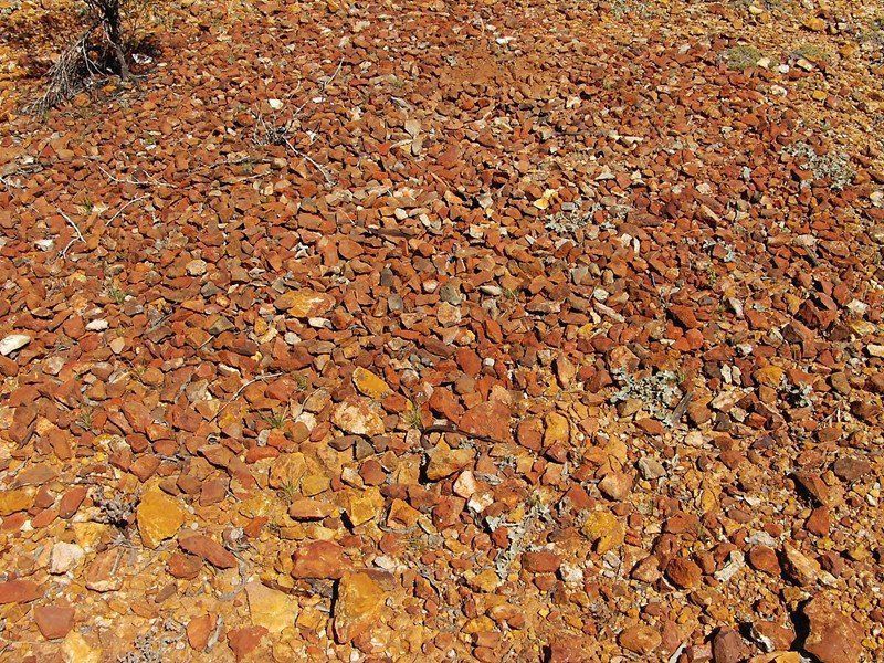
Nightjar this area is in the west australian goldfields. Also there is a fault line about 100m to the north of the area I have taken the shot of. Just to south west of this location out if shot I have taken around a ounce and a half in the past in sub grammars. So I know the area does produce

Shaker, Keep an eye out for small mounds up to about 2m in diameter, we have labelled "mini volcanoes"
Gypsy/Kris wrote a very interesting article a few years back referring them to "fissures"
If you stumble across any of these, "low & slow" and you will be rewarded. Not over the actual mound, surrounding areas up to a hundred metres away.
The make up of these mounds contain rocks not found in surrounding area, hence "mini volcano" almost as if they have been spewed out from far below.
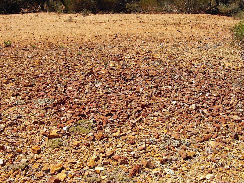
1609493791_archivepotos684.jpg


1609493791_archivepotos686.jpg
 
Hi guys,
Having some geological training, I would say that fault lines and reef lines are similar: part of the same 'spectrum' if you will.

Both require a a plane of weakness in the host rock.

The plane of weakness also has experienced significant movement.

A reef may form where there has been some DILATION (a void or space opened up) into which hot, pressurised liquid can rush in and precipitate minerals (eg :quartz, calcite, pyrite & sometimes gold)
Amazingly, this can occur within seconds (think earthquake) and it is common for reefs to contain chunks of wall rock 'frozen' amongst the quartz etc.

When people describe a fault line, they are talking about a plane of weakness which is dominated by SHEARING where rocks either side of the line grind past or over each other.

To complicate things, both faults and reefs can have multiple movement events, so large faults often contain ground up chunks of reef, and reefs often have shear zones along their edges.
In either case, multiple movements = more potential mineralizing events ?

With the example in this thread, the differing oriented reef and fault suggest 2x distinct events under differing forces, possibly separated by millions of years.

Both have potential to carry gold.

I would pay particular attention to any CONTACT areas (eg: fault meets different rock types, fault meets reef) and CHANGES in GEOMETRY (eg: pinch or swell in a reef, bend or offset in fault)

Hope that makes sense!
Cheers
Drystone
 
CreviceSucker said:
Nightjar said:
WA deposits are generally North/South and reefs run East/West. eg: Kalgoorlie/Menzies/Leonora, with other minesites inbetween.

nice to know , i didnt look at WA maps for ages , many deposits in NSW also appear to be North / South . many of my maps are too big to post here but couple of pics below.

love to see maps covered in glitter...

https://www.prospectingaustralia.com/forum/img/member-images/1804/1594131892_dubbo.jpg

https://www.prospectingaustralia.com/forum/img/member-images/1804/1594132330_moruya..jpg

https://www.prospectingaustralia.com/forum/img/member-images/1804/1594132394_grafton..jpg
There is no overall rule for a State, only generalisations for a particular area (eg in extreme SE NSW, east-west is as common as north-south). Frpm mempry down around Yambulla way etc. Rushworth in Victoria and Nagambie, and White Range east of Alice Springs, would be other east-west examples from memory. Possibly around Pambula, definitely some around Braidwood.

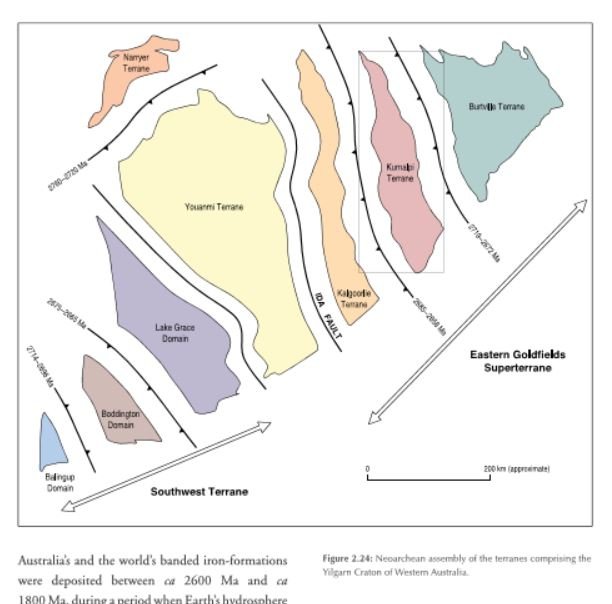
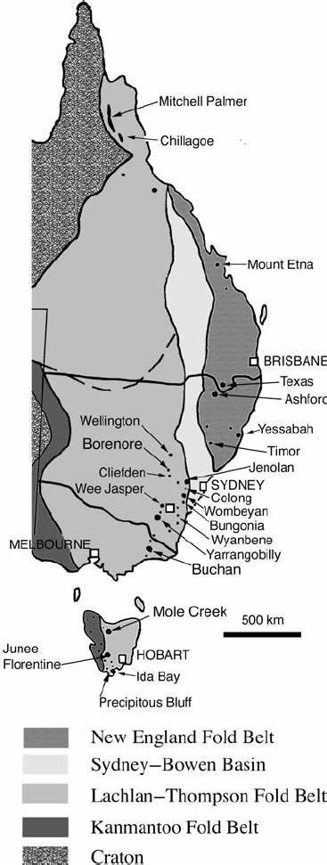
A general observation would be that for the country overall N-S is more common than E-W (because slices of Australia have mostly been added as elongate north-south slices, in a collission process, and the forces involved in adding the slices also produce the fractures in which the gold and quartz is then deposited. But that does not help you much since you are not prospecting all of Australia but a particular locality.

Here are the slices for the Eastern goldfields of WA
1627355432_2_24.jpg


A similar story for eastern Australia:
1627356566_eoz.jpg


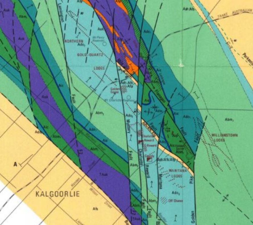
Although one orientation usually predominates in a goldfield or ore body, few have gold-quartz veins that are solely in one direction. Consider central Kalgoorlie - the Northern lodes versus Manitana lodes versus the Williamstown lodes (dotted lines)

1627356158_kalgoorlie.jpg
 
Why is that so goldierocks? I did read once that most faults and reefs are north/south, because of the compression from the east to westward and the resulting uplift. Then why do you end up with east/west reefs in Rushworth and Whroo? Has the area spun around from its original orientation during continental drift, or at some time has there been a compression of the continent from the south or north?
 
That is a damned good question - that you have correctly answered yourself! I'm impressed, are you sure you are not a geologist?

The Pacific ocean floor and the sedimentary rocks and islands on it was for a long time being compressed against Australia from the now east, much of the ocean floor being subducted beneath Australia.

A big lump being carried on the plate - Taswegia or Vandieland or whatever, containing present Tasmania - was on that plate.

It was too large to be subducted beneath the east coast of Australia, so collided with the mainland and rotated itself, so that it was now pushing northwards against mainland Australia.

So now the forces were pushing south to north in eastern Australla, not west to east (farther north the Pacific plate was still pushing west against Australia)

https://www.aig.org.au/wp-content/u...rocline-of-Eastern-Australia-presentation.pdf

see slides 45 to 49 in this presentation
 
Nightjar said:
shakergt said:
Nightjar this area is in the west australian goldfields. Also there is a fault line about 100m to the north of the area I have taken the shot of. Just to south west of this location out if shot I have taken around a ounce and a half in the past in sub grammars. So I know the area does produce

Shaker, Keep an eye out for small mounds up to about 2m in diameter, we have labelled "mini volcanoes"
Gypsy/Kris wrote a very interesting article a few years back referring them to "fissures"
If you stumble across any of these, "low & slow" and you will be rewarded. Not over the actual mound, surrounding areas up to a hundred metres away.
The make up of these mounds contain rocks not found in surrounding area, hence "mini volcano" almost as if they have been spewed out from far below.

https://www.prospectingaustralia.com/forum/img/member-images/1414/1609493791_archivepotos684.jpg

https://www.prospectingaustralia.com/forum/img/member-images/1414/1609493791_archivepotos686.jpg

G'day Nightjar

I have encountered these mounds many times and the first couple I found in my early days at detecting I had a bit of a dig at like you would, finding the centre to be noisy and the soil to be discoloured and fire ash like, many I have found have been dug up in the centre by others who have walked onto them as well, I do agree that these were obviously pushed up from underground, also I think the correct term for it is a "fumerole", I have found evidence of how they form, I came across what appeared to be a shear zone with rocks jutting out of the ground on an angle, one side was facing west or thereabouts and on that side there was a pile of rubble with lots of similar sized pieces of rock that appeared to be the same type and size of the rock that you find on those mounds, the rock pieces are light for their size when compared to similar pieces of other rocks from the area surrounding it, so are obviously made have a different mineral composition.

When I stood back and looked at it the broken down area was semi circular, giving the impression that when the whole structure crumbled to the ground it would appear as a mound not unlike the mounds that we are talking about, the side facing west I imagined was slowly disintegrating due erosion and to heat from the afternoon sun slowly fracturing it and the uniformed sized pieces that come away from it fall to the ground at its base, unfortunately I did not have a camera with me so cant show you pics of it.

cheers

stayyerAU
 
Not fumaroles. Mud volcanoes are not impossible, but where is the mud, That is, they are more likely to be a cold groundwater feature if material is really being brought up from below - but a mud volcanoe will usually form clay pellets that dry and build up, that looks like rock, I once came across one growing on a track near Geraldton, so fast it had blocked the track. But it was entirely a wall of mud pellets, not rock fragments, with a central pool of mud rising and spilling over the wall as drying pellets. This looks more like just an erosional feature, that I would not expect to have any relationship to gold.

But I'm guessing from a photo....

file:///C:/Users/GeneralLaptop/Desktop/Sort/MudVolcanoes.pdf
 

Latest posts

Top