GPS unit and solo prospecting advice needed

Prospecting Australia

Help Support Prospecting Australia:

This site may earn a commission from merchant affiliate links, including eBay, Amazon, and others.
Good question Bacchus.

A lot comes into play here i guess and i dont know if this has ever been tested.

The 406 mHz freq is very sensitive and quite good at sat location from most of the newer units which usually have a 5w + power output.

Remember that once activated, it will transmit for a minimum of 24 hours, this should give enough time for sat location fix as they utilize the geostationary COSPAS-SARSAT satellites. Average total orbit is roughly 100 minutes.
The polar orbit component of the PLB network are LEO (LEOSAR) and circulate at 850km above earth and with the new 406 tech, you only need to fix on one sat to transmit although accuracy would be greater with 2 or more.

Having said that, being stuck in a mine shaft the angle of sky will be rather narrow even compared to a steep valley and lying down there all busted up, you really have no way of knowing if the signal is getting out or not.

Scary stuff indeed and only one of two outcomes here:

If you hear the blades of a chopper approaching, breath a sigh of relief and start blowing on that whistle.

If its been more than 24 hours with no response, lets just hope you have the energy to bend a little and kiss your ass goodbye!

Regards
 
LC76 said:
What the hell are you smoking Doc?
I always get dropped off at a certain location and then hike in to where I want to be.
I nearly always need to mark that drop off location so I can get back to be picked up.

For that I just use an entry level gps to make a way point then turn it of for the day until it's time to return.

I use the mobile phone with appropriate app to track and mark spots of interest take notes ect.

i come from an era before gps 8)
 
Doctor said:
hey peeps it has nothing to do where gold is

if you need a gps to get back to your car , this is another prospective altogether

loosen the grip fellas :p

I don't need a GPS to find my way back to the car. In most cases it gets me to my base camp in a swift bee line so it's my first option of navigation. I reiterate a plan B is always important when walking a long way into the bush.
 
Doctor said:
hey peeps it has nothing to do where gold is

if you need a gps to get back to your car , this is another prospective altogether

loosen the grip fellas :p

Doctor
No one is saying that you should rely on the GPS to get in & out, that is why I added to my 1st post here Map & Compass to me, you need a base understanding in "Map Reading" & "Navigation" to utilise the tools at your disposal.

A GPS is a tool, to find your way back to the car, Mark a Patch location, sample location, transmit (Via Radio) location of injured person, it is a tool that makes your navigational job easier & quicker, it can save you time & energy & prevent you from losing a productive patch.

I think your post's come across way to cryptic to the point where it sounds like your are always having a go at someone, if this is not the case, maybe expand on your post's a little so we can understand them??

Lee
 
Hey Bacchus.

Hypothetically speaking......another option if you ever found yourself in that situation..... big IF I know but...... perhaps you could lob the PLB up out of the shaft to above ground level so it could get a good view of the big sky & do its job.
Only a couple of flaws with this plan.
. It could get busted on landing
. or come come rattling back down on your head 8.(
. or some low life could stumble onto it & knick it while you're laying down there bleeding. :mad:

Hope this little gem helps.

Rob.
 
That's what I'd be aiming for. Depending on the depth and diameter of the mineshaft it could be difficult to lob a PLB out. For all paranoid people with poor aim or weak throwing arm you could assemble another solution

35cm (tiny speargun)
workstupidespadon_1_3.jpg

Smallest PLB (115g)
rde650-large_4.jpg

+
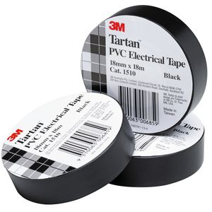
3M0386045_threem_3m_tartan_electric_tape_18x18m_bl_black.jpg

Up to you to figure out how it goes together :)
 
Magellan 710... Love it! One of the top 10 things I've ever owned. Use it hiking, 4wding, motorbike, kayaking, geocaching...

I can be sitting at home looking at Google earth or a topo map, touch the screen on my 710 to the corresponding spot, press GO, and it will take me there turn by turn, and point to point.
it took me nearly 1.5hrs to travel 300m bush bashing the other week, the GPS told me how much further I had to go to get to my destination. Pulled the pin cause I would have run out of time. Mark waypoints at poi's, and can transfer all info to Google earth.
Would never rely on it alone. Research, maps, compass, trail markers etc when required. I don't see a downside to using one, even as a back-up. tool.
 
I did think about the drone idea initially but as cool as it'd be to have a drone to fly your PLB out I went on to factor in lugging this kit around in a pack while prospecting. Figured the quadcoptor would be too bulky to carry in an emergency kit. A compromise it is liek you say. Plan C is dig your way out :lol:
 
Okay Lets get back on Topic a bit!!!

Personally I don't see falling down a shaft as a major concern unless you are running about recklessly !!!!!!!! as most times prospecting you are taking your time unless you are trying to cover some ground to get to an area, obviously you need to be aware of potential hazards in the area you intend working, don't partake in risky behaviour when you are on your own & all should be great fun, "Go & Live a Little"
cheers
Lee
 
Been using GPS`s (Magellans) since the 90`s. Switched over to a smart phone (Android) last gold season, this is brilliant allowed me to run the Oziexplorer app which I`ve been using on PC for years. That combined with a Toshiba R500 ultrabook with Transflective Screen (sunlight viewable) and USB receiver. The R500 can be got off ebay for around $120, allows vehicle navigation with Oziexplorer and saving of smart phone tracks & waypoints. Oziexplorer operates without mobile service, over the years you end up with a priceless gold resource of saved tracks & waypoints that does get you on to more weight.

GPZ GPS ability might make smart phone redundant, certainly will be finding out, smart move by Minelab, hopefully can use Oziexplorer on it rather then Google.
 
Norvic said:
GPZ GPS ability might make smart phone redundant, certainly will be finding out, smart move by Minelab, hopefully can use Oziexplorer on it rather then Google.

Agreed regarding use of Ozi instead of Google, as I believe that Ozi will allow the use of finer resolution than can be achieved on many Google maps. But I will still be taking my Garmin to act as a spot check, target find marker and to allow the bigger picture to be viewed when on the move.

Rob.
 
rc62burke said:
Okay Lets get back on Topic a bit!!!

Personally I don't see falling down a shaft as a major concern unless you are running about recklessly !!!!!!!! as most times prospecting you are taking your time unless you are trying to cover some ground to get to an area, obviously you need to be aware of potential hazards in the area you intend working, don't partake in risky behaviour when you are on your own & all should be great fun, "Go & Live a Little"
cheers
Lee

G'day Lee

I enjoy all your contributions , but on this one mate IMO your comment is way off the mark as falling down a shaft is a major concern
Whilst it may be appropriate for the wide open areas of Qld , we do not all enjoy such a luxury. In SA we have three small designated areas to prospect , at Chapel Hill shafts are sometimes only a few feet apart , severely overgrown and in many cases unseen until you are upon them , one misplaced step and you are on your bum such is the foliage " running around recklessly " !!!!!!! Has nothing to do with it I can assure you , as for going and living a little , I currently fly light aircraft and spend a lot of time fishing out of sight of land and must take an Epirb by law , IMHO a walk around Chapel Hill in its current state is just as dangerous if you wish to detect the mullock heaps and I think anyone who has been there would agree

Cheers
 
I use Ozi have done for many years, I have the PC version and have it on a 7" dash mount tablet with inbuilt GPS antenna and on my Galaxy S3 phone. I use it to plan on PC at home base, to navigate tracks and tracklog whilst driving and very rarely to locate a spot in the bush using the phone.

However I also have the E20 Garmin, Ozi tracks and waypoints can be downloaded (and uploaded) to and from the Garmin. So apart from the safety aspect logging the car, if I want to return to a spot, I mark a waypoint using the E20 and if I want to save it for the next trip I upload to PC and store.

Oziexplorer is only as good as the maps you have, I use 1:250,000 on occasions like planning trips Interstate. 1:100,000 and 1:50,000 intrastate and for track navigation 1:25,000. All maps are Australian Topographical, originally produced by the RAASVY Corp.

I have stitched together individual 25k sheets for areas such as the Goldfields into one map using Ozi's Mapmerge utility, which works well on moving map.
 

Latest posts

Top