GPS and Apps for Ipad

Prospecting Australia

Help Support Prospecting Australia:

This site may earn a commission from merchant affiliate links, including eBay, Amazon, and others.
Hi Anne,

I use memory map and the free map it has. You can also purchase maps but I haven't needed to so far.

I also use a Garmin eTrex 10 in the field to record where my car is and how you get back to it. I also upload designated fossicking area boundaries and old mine info onto it so I know what mines are in the area. I then use a free product from Garmin called Basecamp on my Mac and iPhone to sync the data I collected (tracks, waypoints I.e. Finds) out in the field when I get back home.

There is also a free minelab app on the apple store you could use.

Hope this helps.

Regards,

Grant
 
A little research may score you for free what you are looking for...
Google maps and many others...
Check out the free options it costs nothing to try b4 you buy...
:)

There is even "Talk and Drive - Talk to Google Maps" app... free...
 
some Ipads have built in GPS

there are a few other mapping tools like GISRoam that people here have used on Iphone and Ipads but i couldnt get it to work on mine

going to probably throw my ipad either at the wall or back on ebay
 
I use MemoryMap and GISRoam . Would leave home without them, both make finding gold lots easier. If you have an IPad 1 it might not run GISRoam it needs an Ipad2 and up to handle the large files. iPad2 and newer have built in gps aswell.

DD
 
elrodeo said:
Hey DD hows things ? Heading east soon ?
I knew it just be a matter of time until you'd pop into this thread !!

G'day mate, alls going well except for the heat. It's been 40+ for the last week! Slowing making my way back down to Kal, should be back east in a couple weeks, unless I find a monster on the way ;)

DD
 
FYI HeadsUp - while GISRoam looks like a very professional product I have been using the free app from Avenza called <avenza pdf maps> in iTunes.
So far no problems with Avenza on the iPad & plenty of geo-referenced pdf's for Vic & NSW/ACT from the Sate mapping agencies.
BTW it is also available on the Android platform - just exploring it now - bonus is that IOS/iPad purchased maps will load into Android Avenza without conversion.
Hope this is useful if you want to explore another iPad/Android option.
cheers Jed
 
Jed said:
FYI HeadsUp - while GISRoam looks like a very professional product I have been using the free app from Avenza called <avenza pdf maps> in iTunes.
So far no problems with Avenza on the iPad & plenty of geo-referenced pdf's for Vic & NSW/ACT from the Sate mapping agencies.
BTW it is also available on the Android platform - just exploring it now - bonus is that IOS/iPad purchased maps will load into Android Avenza without conversion.
Hope this is useful if you want to explore another iPad/Android option.
cheers Jed

thanks Jed

funny you should post now , i have spent 5 hours today browsing for a better product , these things are expensive though ( $ 2400 - 3500 )

http://www.handheld-us.com/regions/us/product-overview.asp

http://www.tabletstoreuk.com/all-wi...features/gps-supported-tablets.html?limit=all

I WAS also looking at windows based tablets which are only $ 400 - 800 so that i can also run this site below , it shows me borders of crown land and mining leases so i dont stray anywhere i shouldnt be
it uses FLEX which Apple dont support

http://nswtitles.minerals.nsw.gov.au/nswtitles/

still researching 8)
 
Fate works in funny ways HeadsUp :) Sheer coincidence.

After 6wks away in WA attending family events & buying a ton of jarrah to backload back to Canberra I finally found time to catch-up on the forum postings.
One of the things on my long to-do list was to get back into GPS-based mobile navigation on both the iPad & Android smart phone with 5 inch screen - both things started today!

Need to get my act together mobile navigation wise as I plan to spend 6-7mths in WA in 2014 touring & prospecting.
Like you I like to stay legal so good mobile navigation is critical - the Unauthorised Access fines in WA are now really heavy - for an individual $150,000 (see http://www.dmp.wa.gov.au/10871.aspx#10873)

My current plan is to use both the iPad+Avenza & Oziexplorer Android+Avenza and WA Govt's Tengraph to get the most current info.

A question - is the NSW titles FLEX you mention Apache Flex? see http://en.wikipedia.org/wiki/Apache_Flex

Cheers Jed
 
i emailed the NSW geoscience people about the above issues , his reply is below , (i think you are right , Flex would be the Apache product)

-------------->
The map viewer at http://nswtitles.minerals.nsw.gov.au/nswtitles/ is based on Flex, which doesn't usually work on Apple products like the Ipad (a result of a long standing policy by Steve Jobs not to support Flash or Flex in Apple Products). The department's other map viewer is called MinView (http://minview.minerals.nsw.gov.au/mv2web/mv2). It is based on Java. It may run on an Ipad (I have never tried it as I don't own an Ipad). It partially works on an Android tablet (although some functions don't work as they should). It should run OK on a Windows based tablet (in theory - again, I've never tried it). Both of these sites should run fine on a desktop or laptop computer.

The Department is trying to address the problem you outline. Early in New Year, we will launch a new online web mapping site which is specifically aimed at being functional on mobile devices as well as desktop and laptop computer. It will have all the titles data, as well as a lot of other geological and base data information, and will have a "go to my location" button. The new site is currently in build and testing phase. We are also totally redeveloping MinView to make it fully functional on mobile platforms, but this is not due to be completed until the end of next year.

Regards,
Gary Colquhoun
Senior Geoscientist/GIS Analyst
NSW Department of Trade & Investment
 
Hi Guys, sorry to resurrect this topic... I tried to find GISRoam but it doesn't appear on the App Store. Are there any new apps for victorian goldfields?
 
GISRoam has been discontinued by that company for commercial reasons , they developed a product with better financial gain called Geotrack but you can still download GISRoam from the link below , there is also another similar product called Esri

http://www.esri.com/

http://download.cnet.com/GISRoam/3000-2094_4-75227298.html

Or pick through these and report back on what works for you :)

http://en.wikipedia.org/wiki/List_of_geographic_information_systems_software

i spent about 40 hours trying to get Gisroam to work on my Ipad but the company was unhelpful to get past some glitches with file conversions and i never got it running.

i understand you can convert and import almost any type of map so your Vic ones should be fine.

a member here posted once that he takes high res photos of paper maps , plots GPS reference dots on them and imports this into GIS which enables them with live GPS location while in the field.
 
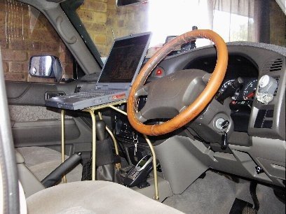
Just wondering how you guys mount your iPads in your 4x4 if you use them for navigation? I want to use Hema as well as run trilobite when I'm out bush and looking for a good way to mount it?
 
Have used this mount since 2002 for my laptop for OziExplorer in my GU Nissan Coilcab.
Still use it now, but place the Samsung Tablet on the open laptop when using Trilobite.

1627981616_laptopmount.jpg

1627981616_laptopmount2.jpg

1627981616_laptopmount3.jpg

1627981616_laptopmount4.jpg

1627981617_laptopmount5.jpg

1627981617_laptopmount6.jpg
 

Latest posts

Top