River Banks NSW

Prospecting Australia

Help Support Prospecting Australia:

This site may earn a commission from merchant affiliate links, including eBay, Amazon, and others.
Joined
Jan 15, 2017
Messages
196
Reaction score
84
Hi all,

There is probably a simple answer to my question but as a newby to fossicking I am a little confused.

I am trying to understand what is classed as the river bank.

Having been to both Grabben Gullen and Tuena, at both spots it appears digging into what I have assumed is the river bank is common practice.

Further the holes that had been dug were not filled in, which I thought was required.

Can anyone provide any insight to this?

Cheers,
Eric
 
Hi Heatho,

Agree.

I guess as a beginner looking at a place like Tuena, everything looks like riverbank to me. So I was not certain where exactly I should be digging.

I chose one of the few spots that didn't look like river bank to me, a spot on a gravel bar between to old dead, fallen trees.
 
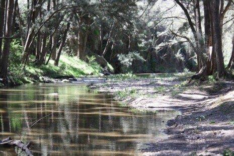
As an example for a beginner, what is classed as the bank?

In the image beliw is it where the current water level is or the highest point which is beyond the tree on the right side?

1489877265_timthumb.jpg
 
You can dig up from the banks just don't dig directly into the side of a river bank above the normal water level. The pay streak of gold is usually in the river itself, you need to sample across the stream or river to find the pay streak. Check out these Wal N Liz vids, they give a good idea of what's required, maybe you've already seen them. I can remember in 1 or 2 of their vids Wal talks a bit about finding the pay streak.

[video=480,360]https://youtu.be/v7VGjH0-Xg4[/video]

[video=480,360]https://youtu.be/qliD5yBmMWU[/video]

[video=480,360]https://youtu.be/JWciIvKqAIQ[/video]
 
When the river or creek is in flood, or flowing normally in a good wet season ,.... I would think the bank would lay in between those two areas ,.... but I'm no hydraulics engineering expert (I'm sure an expert would hold a proper valued opinion). :) :D
just thought I'd add this in, slightly off topic, but that's the beauty of finding other info in your searches, just thought some may find some of the information an eye opener for in the field. (I've only perused a minute portion of the site myself). :D
https://www.jstage.jst.go.jp/browse/prohe1990/38/0/_contents?from=2
 
Thanks all.

Yeah watched many of Wal and Liz's videos which were a big help.

Was more just trying to understand what was classed as the bank.

So it is more the side of the bank, to stop water under cutting and eroding?
 
Eric2017 said:
As an example for a beginner, what is classed as the bank?

In the image beliw is it where the current water level is or the highest point which is beyond the tree on the right side?

https://www.prospectingaustralia.com/forum/img/member-images/9216/1489877265_timthumb.jpg

Ok, in that example, the left side is a definite bank and digging into the side of it will cause erosion, the right side would generally be the area where flood gold might collect anyway as the faster deeper right side would most likely drag the flood gold away. Don't dig around the base of trees either as you would undermine them. I'd say the centre right side where there is gravel and rocks would be no worries to dig, though the far right where there is a small bank you might leave it where it starts rising up again. The left side you'd legally speaking totally avoid digging into.

I'm not great on alluvial knowledge and hopefully some of the other guys will join in this thread.
 
Eric2017 said:
Thanks all.

Yeah watched many of Wal and Liz's videos which were a big help.

Was more just trying to understand what was classed as the bank.

So it is more the side of the bank, to stop water under cutting and eroding?

Yeah exactly right, those steep high banks are the ones where in flood the fastest water will come through and decimate it if it's been damaged by digging into it.

As Wal says in some of his vids, generally there is little point digging into those sides anyway, the pay streak will be in the actual creek itself.
 
G'day All
this is an interesting topic, what is the true definition of a river bed and a river bank , my interperation of the river bed is that area which captures the flow of water, at the maximum flow hence sometimes described as the high-water mark, and the river bank is the area of land supporting the earth above that high water mark. Remember that mother nature can change the course of a watercourse at any time and do you look at the surrounding trees and to see just how high the flood waters get , do my thoughts make sense , what doesn't make sense is the definition of fossicking, particularly no excavation amongst the approved methods below is the exact wording used :

"Fossicking can be done on land or waters subject to native title using hand held implements, which include picks, shovels, hammers, sieves, shakers and gold pans. However, regardless of the implements used, no excavation is permitted."

"On land or waters that are not subject to native title, fossicking is not restricted to hand held implements, but power-operated equipment cannot be used for the purpose of surface disturbance, excavation or processing."

"Metal detectors can be used in fossicking activities on any land where fossicking is permitted."
 
G'day All

more fat to chew on, the following is an extract from
CROWN LANDS ACT 1989 - SECT 172
Land with boundaries to lakes, roads etc
172 Land with boundaries to lakes, roads etc

(1) In this section:

"alienated" (except in subsection (7)) means sold, leased or otherwise disposed of under the Crown Lands Acts or any other Act relating to the alienation of land of the Crown.

"bank" means the limit of the bed of a lake or river.

"bed" means the whole of the soil of a lake or river including that portion:
(a) which is alternately covered and left bare with an increase or diminution in the supply of water, and
(b) which is adequate to contain the lake or river at its average or mean stage without reference to extraordinary freshets in time of flood or to extreme droughts.

"lake" includes a permanent or temporary lagoon or similar collection of water not contained in an artificial work.

"river" includes any stream of water, whether perennial or intermittent, flowing in a natural channel, and any affluent, confluent, branch or other stream into or from which the river flows.
(2) The boundary of any land which is alienated by the Crown and which is described or alienated:
(a) as bounded by, by reference to, or by the margin or bank, of a non-tidal lake, or
(b) by metes expressed or shown to run to a lake or to the margin or bank of a lake,
shall be taken to be the bank of the lake at the time of the Crown survey for the purposes of the alienation.
(3) Title to land comprising the bed of a non-tidal lake does not pass, and never has passed, by any alienation of land adjoining the lake:
(a) as bounded by, by reference to, or by the margin or bank of, the lake, or
(b) by metes expressed or shown to run to the lake or to the margin or bank of the lake,
and no person is, by being the owner of land so alienated, entitled to any rights of access over, or to the use of, any part of the bed.
(4) The doctrine of accretion does not apply, and never has applied, to a non-tidal lake.
(5) A person is not, by being the owner of land sold, leased or otherwise disposed of under this Act or the Crown Lands (Continued Tenures) Act 1989 :
(a) as bounded by, by reference to, or by the margin or bank of, a river, or
(b) by metes expressed or shown to run to a river or to the margin or bank of a river,
entitled to any rights of access over, or to the use of, any part of the bed of the river.
(6) Subsection (5) does not apply to the owner of land sold under the Crown Lands (Continued Tenures) Act 1989 if the land:
(a) was, at the time of the sale, held as a conditional lease, homestead selection, homestead farm, week-end lease, conditional purchase lease, settlement purchase lease, closer settlement lease or group purchase lease under the Crown Lands Acts, and
(b) was held as that holding before the bed of the adjoining river was reserved from sale or lease under the Crown Lands Acts.
(7) If, before the commencement of this section:
(a) the bed of a river was reserved from sale or lease under the Crown Lands Acts, and
(b) land adjoining the river was subsequently alienated (including alienation under any form of tenure under the Crown Lands Acts or any other Act relating to the alienation of land of the Crown):
(i) as bounded by, by reference to, or by the margin or bank of the river, or
(ii) by metes expressed or shown to run to the river or to the margin or bank of the river,
a person is not, by being the owner of the land, entitled to any rights of access over, or to the use of, any part of the bed of the river.
(8) If any land is or was alienated by the Crown with a boundary adjoining, or as bounded by, a road created by the Crown, no part of the road passes, or shall be taken ever to have passed, with the land.
(9) Nothing in this section affects any rights acquired under the Water Management Act 2000 .
 
Anyone ever get the feeling you need to get a law degree before taking up this hobby?

To me personally l have always considered the bank in terms of the legislation to be any area on the sides of a creek or river that digging into would lead to a significant increase in erosion. So stick to the inside of bends where the gravel has dropped no worries, but stay clear of the outside of the bend where the creek is slowly eating away.
 

Latest posts

Top