Gold Detecting, Fossicking and Prospecting in NSW. Information and questions.

Prospecting Australia

Help Support Prospecting Australia:

This site may earn a commission from merchant affiliate links, including eBay, Amazon, and others.
PabloP said:
Perhaps a series of links back to existing items elsewhere on the forum is the best way. As you come across an item, check if in the relevant area and if not post a link to it.

Rob.

That's a great idea!
 
NSW research sites:
https://minview.geoscience.nsw.gov.au/
Fossicking Districts
Within a fossicking district, a person can go onto an exploration licence for the purpose of fossicking without the licence holder's consent, provided they have the permission of the landholder. A fossicking district may cover a small area, or an entire shire.

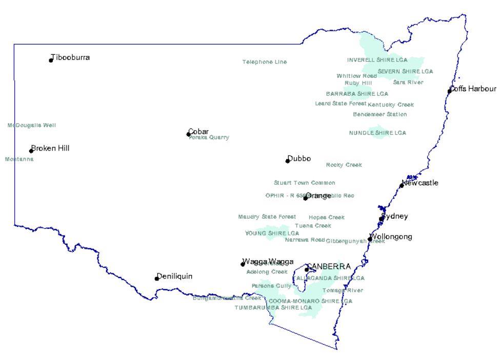
1431167302_capture.jpg


NSW Fossicking Districts
TUMBARUMBA SHIRE LGA 7 L98/0394 Notified at the request of Tumbaruma Council
COOMA-MONARO SHIRE LGA 5 L98/0394 Notified at the request of Cooma-Monaro Council
TALLAGANDA SHIRE LGA 8 L98/0394 Notified at the request of Tallaganda Council
YOUNG SHIRE LGA 6 L98/0394 Notified at the request of Young Council
SEVERN SHIRE LGA 2 T97/0535 Notified at the request of Severn Council
BARRABA SHIRE LGA 9 L99/0610 Notified at the request of Barraba Shire Council
NUNDLE SHIRE LGA
INVERELL SHIRE LGA

OPHIR - R 65909 for Public Rec 1 L97/0303 Notified at the request of Cabonne Council over Reserve No 65909 for Pub Rec

Campbells River 10 M92/0417 Former Fossicking Area No 4
Abercrombie Caves 11 M92/0417 Former Fossicking Area No 5 M74/3530
Sofala Common 12 M92/0417 Former Fossicking Area No 8 M74/3530
Blackguard Gully 13 M92/0417 Former Fossicking Area No 10 M75/4551
Abercrombie River 14 M92/0417 Former Fossicking Area No 14 M75/4547
Tuena Creek 15 M92/0417 Former Fossicking Area No 17 M78/2177
McDougalls Well 16 M92/0417 Former Fossicking Area No 18
Rocky Creek 17 M92/0417 Former Fossicking Area No 19
Sara River 18 M92/0417 Former Fossicking Area No 20
Bora Creek 19 M92/0417 Former Fossicking Area No 24
Kentucky Creek 20 M92/0417 Former Fossicking Area No 25
Telephone Line 21 M92/0417 Former Fossicking Area No 29
Adelong Creek 22 M92/0417 Former Fossicking Area No 32 M75/3567
Tambaroora 23 M92/0417 Former Fossicking Area No 34 M75/2475
Ruby Hill 24 M92/0417 Former Fossicking Area No 35
Bodalla State Forest 25 M92/0417 Former Fossicking Area No 38
Jones Swamp Gully 26 M92/0417 Former Fossicking Area No 39 M74/4225
Montanna 27 M92/0417 Former Fossicking Area No 40
Whitlow Road 28 M92/0417 Former Fossicking Area No 41
Grabben Gullen Creek 29 M92/0417 Former Fossicking Area No 42
Grabben Gullen Creek 30 M92/0417 Former Fossicking Area No 43
Grabben Gullen Creek 31 M92/0417 Former Fossicking Area No 44
Hopes Creek 32 M92/0417 Former Fossicking Area No 46 M75/3518
Hopes Creek 33 M92/0417 Former Fossicking Area No 47 M75/3518
Hopes Creek 34 M92/0417 Former Fossicking Area No 48 M75/3518
Long Creek 35 M92/0417 Former Fossicking Area No 49
Poraka Quarry 36 M92/0417 Former Fossicking Area No 52
Poor Mans Gully 37 M92/0417 Former Fossicking Area No 55
Stuart Town Common 38 M92/0417 Former Fossicking Area No 56
Stuart Town Common 39 M92/0417 Former Fossicking Area No 57
Tumbarumba Creek 40 M92/0417 Former Fossicking Area No 58
Leard State Forest 41 M92/0417 Former Fossicking Area No 61
Gibbergunyah Creek 42 M92/0417 Former Fossicking Area No 62
Yarrow River Bridge 44 M92/0417 Former Fossicking Area No 64
Bungambrawatha Creek 45 M92/0417 Former Fossicking Area No 65
Bendemeer Station 46 M92/0417 Former Fossicking Area No 66
Waterfall Creek 47 M92/0417 Former Fossicking Area No 67
Waterfall Creek 48 M92/0417 Former Fossicking Area No 68
Riverside 49 M92/0417 Former Fossicking Area No 69
Maudry State Forest 50 M92/0417 Former Fossicking Area No 70
Parsons Gully 51 M92/0417 Former Fossicking Area No 71
Golden Gully 52 M92/0417 Former Fossicking Area No 72 M79/0347
Tomaga River 53 M92/0417 Former Fossicking Area No 73 M80/3580
 
Hello, I am very new to prospecting, live in Gol Gol NSW. Heading up to Pooncarie today for a drive, not sure if any areas am able to try out my Fors gold detector, has anyone been around the Pooncarie area? I will also try around Broken Hill at a later date. Cheers
 
BUREAU OF MINERAL RESOURCES, GEOLOGY AND GEOPHYSICS
Resource report 6
Gold Deposits of NSW: BMR datafile (MINDEP) by C.M. Mock
http://www.ga.gov.au/corporate_data/22203/Res_Rep_06.pdf
DEPARTMENT OF PRIMARY INDUSTRIES AND ENERGY said:
ABSTRACT
Data are presented for 60 New South Wales gold deposits. They include information on regional setting, geology, and characteristics of the deposits and their host rocks, including deposit type and proposed genetic models. Development history (including discovery and mining methods), resource and production data, and a bibliography are also presented. The data form part of BMR's mineral deposits (MINDEP) database.
Its about 28MB to download.
 
What is the easiest way to find out where public access areas are for well known locations ? , I was expecting to be able to find maps with private and public land marked but haven't had much luck yet ?

The general rule with fishing is if you stick to the water coarse you can follow any creek , the fossicking guide reads to me that landholder permission is necessary which is fair enough as I wouldn't want uninvited people prospecting on my farm.
 
aussiefarmer said:
What is the easiest way to find out where public access areas are for well known locations ? , I was expecting to be able to find maps with private and public land marked but haven't had much luck yet ?

The general rule with fishing is if you stick to the water coarse you can follow any creek , the fossicking guide reads to me that landholder permission is necessary which is fair enough as I wouldn't want uninvited people prospecting on my farm.

I think I have just answered my own question thanks to the wealth of information you blokes are sharing on here ,

Who would have thought it would be this complicated , to protect locals their should be maps for each area with public areas marked clearly and it should be compulsory to carry it when prospecting.

Thanks to all for the great site , it really is answering some questions for a newbie like me.
 
Hi guys, bit of a novice but at the age of 48 looking for a hobby to grow old(er) staying active outdoors.
Not long done a day out with Coiltek from Maryborough Vic. Thumbs up Eddie by the way, good fun.
Still yet to invest in a decent detector but during my Youtube research have come across heaps of videos from the gold areas of W.A.
These all seem to have the common denominator of lots of rocky reefs and quartz all over the joint.
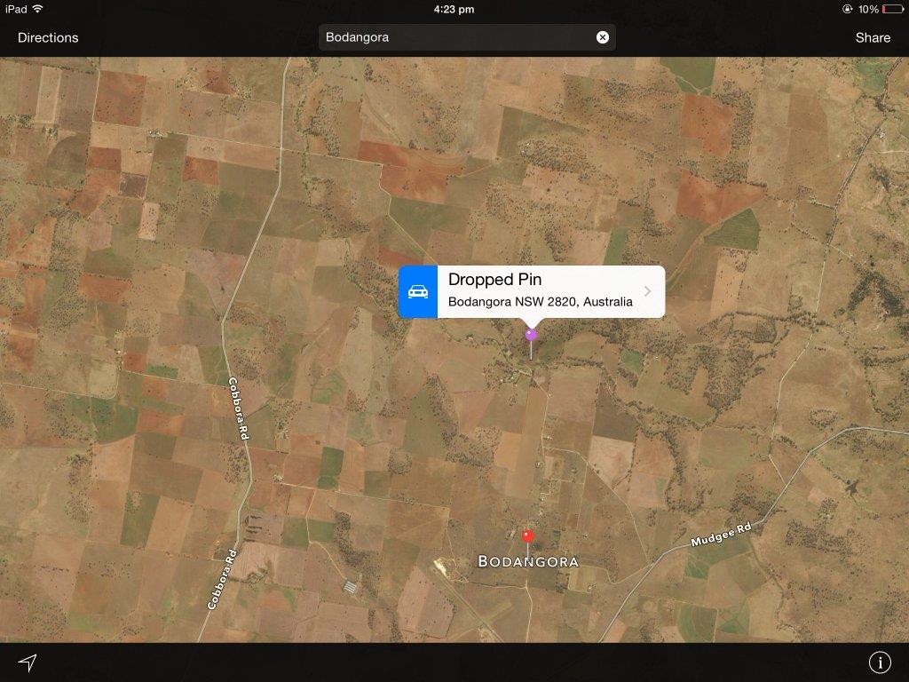
This reminded me of a place I used to go as a younger bloke, north of Broken Hill in the Fowlers Gap area.
I've included a couple of old pictures of the area from the early 90's which don't translate too badly to digital.
I'd love some input from people with more knowledge than I (and that's a pretty big pool to dip into) as to whether it's worth the 10 hr drive from where I live in Victoria to wave a detector around up there.
Thanks in advance.
1441190156_photo_1 (2).jpg

1441190189_photo_2 (2).jpg
 
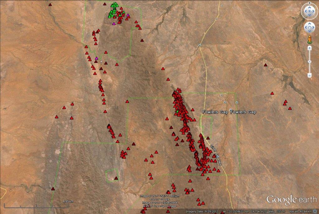
There are Gold deposits about 10km SW of Fowlers Gap, just not well known ones, there also also large deposits of Tourmaline and Garnets, small deposits of Beryl and Diamonds present also. NW of Fowlers Gap there is Tourmaline and Amethyst. If I lived out there I'd be very busy checking out all these depoits as there is a lot of Pegmatites and the region is very mineralised. Red triangles are metalic minerals, green are gemstones. Although the deposit below is a Sulphide deposit I'd say there would be areas worth trying with a detector out there.

1441316420_fowlers_gap.jpg


Metallic and Industrial Deposits
183613 -
()
Coords: -31.512641,141.595580
Mga_coordsys: MGA_54S
Mga_north: 6513428
Mga_east: 556552
Loc_method: 50K
Accuracy: 50
Major_comm: Cu, Au, Fe
Size_code: OCC
Comm_type: METMIN
F_prefix: GT
F_no: 0101
Met_prefix: BROKEN HILL
Met_no: 0551
Hist_map: GT0101
Geo_province: Broken Hill Domain
Metal_dist: Euriowie Block
Op_status: ceased
Op_method: pit(s)
Lga: Unincorporated
Locality: County Farnell, Parish Coonbaralba, Portion WL 3162
Strike: 35
Work_desc: shallow pits
Compiler: GR Burton 29/11/1993
Last_update: 1994-08-09
Occur_size: Occurrence only
Update_hist: Recorded by G Burton 29/11/1993, Updated by G Burton 09/08/1994, Migrated by PM Downes 2/9/1999
Notes: dominion mining limited did rock chip geochemical sampling in 1991. Samples 856412-416 taken. Significant respective assays gave: 9700ppm Cu; 3.85% Cu, 0.46ppm Au; 3.20% Cu, 0.22ppm Au; 5.25% Cu, 0.37ppm Au; 3.70% Cu. four pits developed on mineralised zone which is about 70 m long. Consists of layers and pods of quartz-iron oxide rock up to 9 m long and up to 0.8 m wide. retro foliation strikes 032, 40 deg se dip. disseminated, blebby, stringy, reticular iron oxide has a patchy to layered distribution. Layers are several centimetres wide, parallel to the retrograde foliation and defined by variations in quartz:iron oxide ratio. Possible gradational contact with host rock. Host contains disseminated iron oxide and malachite coats. Suspect tight fold hinge just north of southern pit, plunges 35 deg to 055 with fold axis parallel to retrograde foliation. Abundant quartz in hinge area. Some quartz fragments are glassy and vein-like and may represent remobilised mineralisation. They contain black micaceous (biotite/chlorite) inclusions. One bedding measurement: strikes 076, 72 deg NW dip, but probably variable. linear zone of quartz-iron oxide pods and lenses with secondary Cu.
Major_source: field checked
Commodities
Cu MAJOR
Au MAJOR
Fe MAJOR
Current Resource Estimates
---
Production
---
Minerals
Chrysocolla major ore
Limonite major ore
Malachite major ore
Azurite minor ore
Biotite major gangue
Chlorite major gangue
Feldspar major gangue
Host major gangue
Quartz major gangue
Mineralisation Style
Disseminated
Host Rock
Allandale Formation (metasedimentary schist/gneiss) Variably Retrogressed Quartz-feldspar-biotite+/-garnet+/- Sillimanite Schist. (Statherian -> Statherian)
Relation to Host
Stratiform
Alteration
---
Ore Texture
---
Placer
---
Classification
Great Eastern type (pyrite, Cu, Co) Broken Hill or Other Classification
iron formation General geological model sedimentary
Structurally controlled high sulfide base metal (+/- Au) NSW Deposit Type Classfication
Deposit Shape
---
Stuctures
Shear
Tenements
---
Project References
---
References
Burton G.R. (1995) Metallogenic study and mineral deposit sheets of the Euriowie Block Central area 2015-09-03 DocType:GS Report GS:GS1995/115 DIGS:R00000255
(1992) 2015-09-03 GS:GS1992/267
 
If you do a bit of scratching there are some recorded old workings out that way noted as "shallow pit". That would indicate to me a good possibility of detectable gold.
Get onto Minview

- Tick the "I agree to the conditions of use for this site" box then click on "Minerals View"
- Untick "Mineral Drill Holes" & tick "Rivers" & "Roads" boxes (to get better bearings - use in conjunction with a mapping program i.e. Google Maps/Earth)
- Press the "Mineral Occurrences" + for the drop down list & tick the "Gold" box
- Zoom into the area using the action buttons on the top of the page. The gold deposits are all south of Fowlers Gap
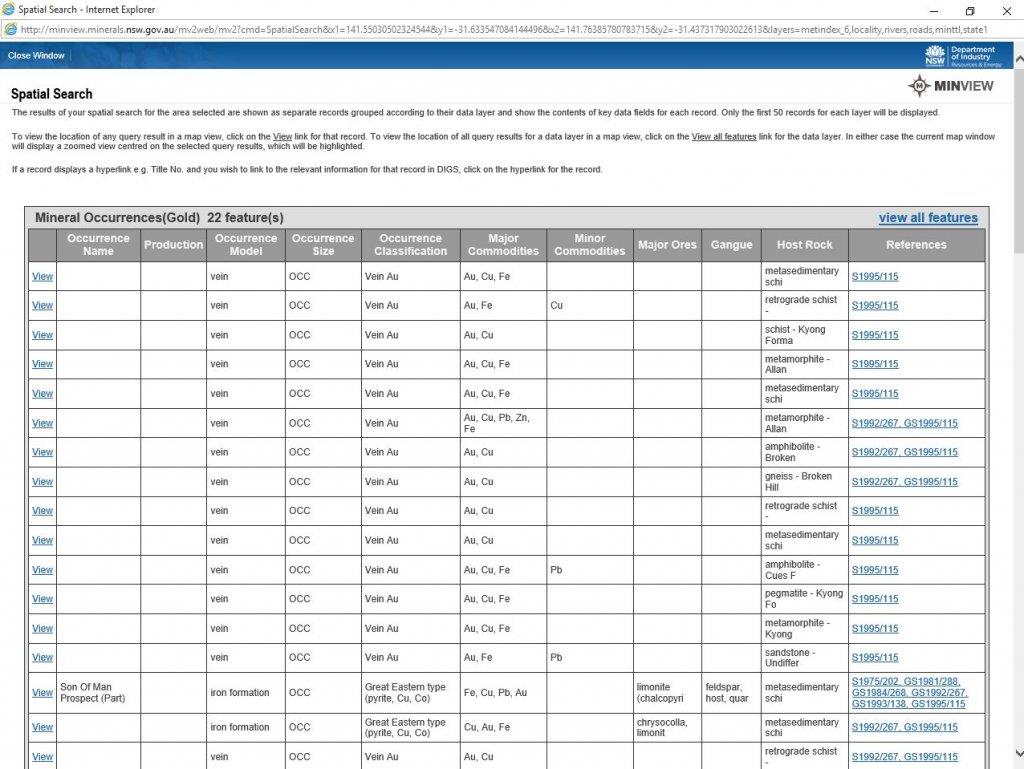
- to view reports on the area click on the ? action button. A + will come up as your screen pointer which you can use to click & drag over an area of interest. A Spatial Search window will come up:
1441330702_capture.jpg

On the far right you can click on the links under "References" to various reports on the area.
Down the bottom of the page there is also a section on current Minerals Titles reports. You can get DIGS reports here also.
1441330857_capture2.jpg


If you do no good you can always head further north to Milparinka/Tibooburra or work your way back south through other areas?
 
"Hi guys, bit of a novice but at the age of 48 looking for a hobby to grow old(er) staying active outdoors.
Not long done a day out with Coiltek from Maryborough Vic. Thumbs up Eddie by the way, good fun.
Still yet to invest in a decent detector but during my Youtube research have come across heaps of videos from the gold areas of W.A.
These all seem to have the common denominator of lots of rocky reefs and quartz all over the joint.
This reminded me of a place I used to go as a younger bloke, north of Broken Hill in the Fowlers Gap area.
I've included a couple of old pictures of the area from the early 90's which don't translate too badly to digital.
I'd love some input from people with more knowledge than I (and that's a pretty big pool to dip into) as to whether it's worth the 10 hr drive from where I live in Victoria to wave a detector around up there.
Thanks in advance."

Umm, why not first spend the time on Vic goldfields that are closer to where you live? No need to spend 10 hour drives in the beginning
 

Latest posts

Top