Hi Folks,
Thanks for all of the support and help you've been over the past few months! it's appreciated and I'm learning lots. So I'd like some assistance in deciphering, for want of a better term, Doug Stone maps or, in general, any detecting map & GeoVIC data. I'll reference the Beaufort map that I have as that's right in front of me.
I've learnt a few important things:
1) Deep Lead mining is not the same as Quartz Reef Mining - I was, previously, of the view that if there was a shaft that the old timers were getting reef gold but that thought has been corrected. Deep lead mining refers to accessing alluvial gold in old stream beds etc that are meters under the surface.
2) Alluvial Gold doesn't just refer to the stuff sitting close to the surface - it can also be associated with old rivers etc meters underground
I've been comparing Doug Stone maps with GeoVIC data and trying to get some correlation between the two... I've noticed, and I'm particularly looking around Beaufort/Chute, that what the Doug Stone map refers to as Quartz Reef (i.e. Waterloo Lead) the GeoVIC data refers to as Deep Lead Lines. I also noticed that GeoVIC seems to include more of these Deep Lead lines than is referenced on the Doug Stone maps i.e. Doug Stone references the Waterloo Lead with several offshoots including a short Sulky Lead. GeoVIC references a much longer and branchier Sulky Lead around Chute and more detail along the Waterloo Lead. Why is that? and here, where GeoVIC reference Deep Lead Lines, are they referring to Quartz Reefs?
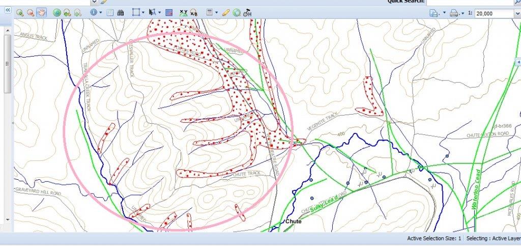
I've also noticed that the Quartz Reefs (Doug Stone)/Deep Lead Lines (GeoVIC) seem to lay in gullys and the Gold Diggings (Doug Stone)/Shallow Workings (GeoVIC) seem to extend uphill. I thought the gold was shedded from the reefs and would have then run downhill - or is it possible that the gullys that the gold is in now was once lower than the area through which the Quartz Reefs/Deep Leads run? The below picture kind of shows what I mean. Can anyone explain what I'm seeing?

In the pink circled area, by my very novice thought, the reef should, theoretically, be on the ridge top for the gold to run down the gullies in the above picture headig down toward the deep lead line.
Also, when the Doug Stone Maps/GeoVIC maps refer to Gold Diggings/Shallow Workings does this mean surface gold or can it also reference deep lead mining? In the majority of areas where Gold Diggings are referenced there aren't any shafts shown so I'm assuming that it's nearer the surface. Also, if there is a shaft pinpointed in a gold diggings area would that typically mean that the gold is deeper than the realms of a detector?
Also, how is it that there can be pockets of gold diggings so far away from the Doug Stone referenced quartz reefs or is it possible that not all of the quartz reefs/sources are known? The Beaufort map pretty much suggests that any water course in that area has gold... How does Doug Stone, or GeoVIC for that matter, determine the extent of the gold diggings? is it simply a combination of historical data and geological information?
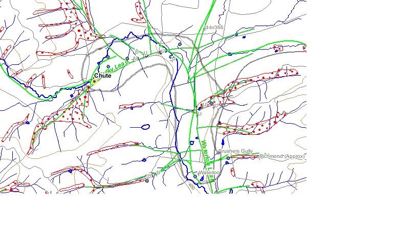
Also, I noticed on the GeoVIC map around Chute that there's two slighty different coloured deep lead lines - what does that mean? they both seem to follow quite closely to each other but are slightly different shades of green. You can see them both in the above image.
Apologies for all of the dumb questions but I thank you for your patience in helping...
Thanks for all of the support and help you've been over the past few months! it's appreciated and I'm learning lots. So I'd like some assistance in deciphering, for want of a better term, Doug Stone maps or, in general, any detecting map & GeoVIC data. I'll reference the Beaufort map that I have as that's right in front of me.
I've learnt a few important things:
1) Deep Lead mining is not the same as Quartz Reef Mining - I was, previously, of the view that if there was a shaft that the old timers were getting reef gold but that thought has been corrected. Deep lead mining refers to accessing alluvial gold in old stream beds etc that are meters under the surface.
2) Alluvial Gold doesn't just refer to the stuff sitting close to the surface - it can also be associated with old rivers etc meters underground
I've been comparing Doug Stone maps with GeoVIC data and trying to get some correlation between the two... I've noticed, and I'm particularly looking around Beaufort/Chute, that what the Doug Stone map refers to as Quartz Reef (i.e. Waterloo Lead) the GeoVIC data refers to as Deep Lead Lines. I also noticed that GeoVIC seems to include more of these Deep Lead lines than is referenced on the Doug Stone maps i.e. Doug Stone references the Waterloo Lead with several offshoots including a short Sulky Lead. GeoVIC references a much longer and branchier Sulky Lead around Chute and more detail along the Waterloo Lead. Why is that? and here, where GeoVIC reference Deep Lead Lines, are they referring to Quartz Reefs?
I've also noticed that the Quartz Reefs (Doug Stone)/Deep Lead Lines (GeoVIC) seem to lay in gullys and the Gold Diggings (Doug Stone)/Shallow Workings (GeoVIC) seem to extend uphill. I thought the gold was shedded from the reefs and would have then run downhill - or is it possible that the gullys that the gold is in now was once lower than the area through which the Quartz Reefs/Deep Leads run? The below picture kind of shows what I mean. Can anyone explain what I'm seeing?

In the pink circled area, by my very novice thought, the reef should, theoretically, be on the ridge top for the gold to run down the gullies in the above picture headig down toward the deep lead line.
Also, when the Doug Stone Maps/GeoVIC maps refer to Gold Diggings/Shallow Workings does this mean surface gold or can it also reference deep lead mining? In the majority of areas where Gold Diggings are referenced there aren't any shafts shown so I'm assuming that it's nearer the surface. Also, if there is a shaft pinpointed in a gold diggings area would that typically mean that the gold is deeper than the realms of a detector?
Also, how is it that there can be pockets of gold diggings so far away from the Doug Stone referenced quartz reefs or is it possible that not all of the quartz reefs/sources are known? The Beaufort map pretty much suggests that any water course in that area has gold... How does Doug Stone, or GeoVIC for that matter, determine the extent of the gold diggings? is it simply a combination of historical data and geological information?
Also, I noticed on the GeoVIC map around Chute that there's two slighty different coloured deep lead lines - what does that mean? they both seem to follow quite closely to each other but are slightly different shades of green. You can see them both in the above image.
Apologies for all of the dumb questions but I thank you for your patience in helping...


