Advice on GPS units

Prospecting Australia

Help Support Prospecting Australia:

This site may earn a commission from merchant affiliate links, including eBay, Amazon, and others.
Hi Ridge Runner,
Our detecting group all use Uniden 5 watt radios, model UHO78SX in my case, they are built like tanks and give great service, mine, I have two, are five or so years old and have been great with no problems; due to their construction they are a little heavier than other plastic cased radios; Google Uniden to check out their 5 watt radios. The GPS in the picture is a Garmin Montana 650T which has a larger than average screen and very user friendly in the bush.
Garmin's Basecamp software on PC or laptop coupled to the GPS and you can do vertually any procedures you are likely to require in terms of mapping ,tracks, waypoints and swap data back and forth between computer and GPS, very handy.
Cheers, SinHof.
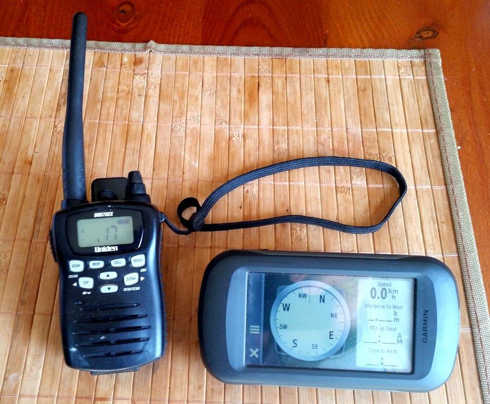
1483839512_20170108_113139.jpg
 
Thanks, they look great, I have bought so many radios that seem to be fairly short range, I bought 2 40 channel 5 watt FM CB's and they were useless past 500 meters, I could hear every one else from miles around but no one could hear me. but your one looks just the ticket.

Thanks again,

John.
 
I'm looking at getting a ICOM IC41pro 5w hand held and a Garmin GPS - I want to be safe and able to get in touch with anyone shoukd I need too
The ICOM is around $300 on eBay and the Garmin around $650 do not a cheap combo!
Anyone out there use ICOM hand held UHF units?
 
Steve V2.0 said:
I'm looking at getting a ICOM IC41pro 5w hand held and a Garmin GPS - I want to be safe and able to get in touch with anyone shoukd I need too
The ICOM is around $300 on eBay and the Garmin around $650 do not a cheap combo!
Anyone out there use ICOM hand held UHF units?
Yes! I work as a traffic controller, and we use them daily. I have seen many T/C companies and councils try to use cheaper options and they all fall short, it is far and away the best handheld available for distance, quality of reception and battery life. It is TX that uses up the battery, and these will do 10 - 12 hours constant use on the highway on one charge. Unfortunately also one of the most expensive, but "you get what you pay for"
 
My old etrex used to interfere with the 4500. My screen has now started to pack up so I will have to update.
 
This topic has been "done to death" :) on the Forum, do a search.

Try the following search

gps+garmin+navman+hema+uniden

That will probably bring up more brands and names as well.......
 
Hi, in the process of buying a GPS, thinking maybe Garmin Map 64s. Just wondering if it is worth buying the lite or full Topo maps or to just download my own google earth maps? How easy is it to make and load your own maps?

Any hints would be much appreciated, thanks, K.
 
kurra said:
Hi, in the process of buying a GPS, thinking maybe Garmin Map 64s. Just wondering if it is worth buying the lite or full Topo maps or to just download my own google earth maps? How easy is it to make and load your own maps?

Any hints would be much appreciated, thanks, K.

That's the GPS that I use. Bought it because it has the external antenna and better satellite coverage in dense bush than ones without. (according to the research I did) I bought my topo maps off eBay for $20 - $25. Not sure what was going on there as in the shops there around $200. The ad says its refurbished topo maps on a micro sd card. Loaded it up and away i went.

I usually make up waypoints and tracks on Google Earth and convert the Earth files into a file that's compatible to upload into the Gps. This works a treat when I have overlayed an old timers map onto Earth and want to get precise locations from that map into the Gps. I've done a few videos that show the whole process from start to finish if you want to have a look. Can't load up links because im only at 4 posts so you may have to cut and paste. Just copy the code below each title into Youtube search and the videos should come up. If that doesn't work try typing in the title into youtube search.

Video 1.
Uploading Google Earth files to a GPS for gold prospecting
oKje6GCeEnI

Video 2.
Overlaying Prospecting Maps Onto Google Earth
beJ8ouRJGpU
 
Thank you RichterScale, just took a look at you video,s and they look exactly like what I need to get me started. Thank you so much for posting.

Glad you find the Garmin 64s works well for you. I've been going round in circles trying to decide on the best one for my needs, cheers,K
 
Im thinking of buying the Garmin 78 hand held GPS that has the ability of installing a MicroSD card with a topographical map of Australia. The price of a new topo map is about $150.00 (the one that has 10 meter contours) but I see that they are also listed on fleabay as refurbished for about $25.00. Generally the refurbished ones seem to have good reviews, but Im wondering whether they are Chinese copies masquerading as refurbished originals.

Has anybody used the 78 and in particular with one of those refurbished maps? What are your thoughts?

Zol
 
They work fine, but, if you look hard enough in the right places you can download them for nothing, like most maps on fleabay.
 
Anolphart said:
Im thinking of buying the Garmin 78 hand held GPS that has the ability of installing a MicroSD card with a topographical map of Australia. The price of a new topo map is about $150.00 (the one that has 10 meter contours) but I see that they are also listed on fleabay as refurbished for about $25.00. Generally the refurbished ones seem to have good reviews, but Im wondering whether they are Chinese copies masquerading as refurbished originals.

Has anybody used the 78 and in particular with one of those refurbished maps? What are your thoughts?

Zol

I have owned the 76 for about 10 or 15 years and I bought the 72 about 2 years ago, I love how simple they are, I don't like GPS's with maps in because I only want my info in there, they draw their own map of where I have been, and they have multiple data fields if you need them, They can zoom in to about 20 feet or 6 metres from memory and the 76 has major towns and cities in it, I like the bigger screens they have, I also have one of the Garmin Street Pilot III for dash mounting and it has worldwide mapping but I keep it turned off again because I just want it to record what I am doing.

Battery life on the 72 and the 76 is about 24 hours running on 2 AA's which is pretty good but if you use Energizer Lithium you will at leased double that time. I have tried the cell phone thing but using the GPS in a phone sucks the life out of the battery, I also have 2 of the American Army Issue Cammenga Compasses the ( 3H ) which has self powered illuminous cardinal point made out of Tritium and I also have the model 27 version as well for backup which just has the normal illuminous markers.

hope that helps.

John.
 
Thanks for your input guys. I have had several GPSs and own the current Etrex10 to get me back to my car, but I want to hike into some new areas and I would normally take a detailed topo paper map with me so I figured it would be cheaper in the long run to use the electronic version.

1513573259_lost.jpg
 
Anolphart said:
Thanks for your input guys. I have had several GPSs and own the current Etrex10 to get me back to my car, but I want to hike into some new areas and I would normally take a detailed topo paper map with me so I figured it would be cheaper in the long run to use the electronic version.

https://www.prospectingaustralia.com/forum/img/member-images/11434/1513573259_lost.jpg

Well I would still carry the maps because they don't have batteries to run flat, and it pays to have a backup plan just in case, all those things need to be carried on your person and not in a pack, I always like to have a couple extra backup plans to fall back on.
 
Maps are best if you can get them and use the god as a check nav, to make sure you are where you think you are.
I only ever saw garmin being used in the army.
 
To answer the original Q.

A few years ago, I wanted the Topo maps for my old ETrex, so I bought a $25 Fleabay special. The ETrex (B&W) had a base map which was very basic, when I looked to install the Fleabay map, I found that it was the same base map I already had. It was advertised as Topo. I contacted the seller, informing them that I would seek Paypal resolution if they did not refund. I got my money back and they did not ask for the SD card to be returned. So Buyer Beware.....

I now use the Etrex E20 (it was a freebie when I bought the 5000) I bought the Garmin $150 maps for it. However, a few tips for using any handheld.......

1. To conserve battery, switch it on at the car, have a waypoint named CAR, reset its position to your current location, then turn off the GPS. Only turn it back on if needed to find the car.

2. Preparation - To navigate to a pre selected spot - carry paper maps if you wish, I don't, as I have Oziexplorer and a lot of Topo mapping for it at 25k scale. If I pre plan a location/s on Ozi (laptop) I mark those with a Waypoint then transfer them to the E20, then use it to navigate there. Once there, I turn the GPS off.

3. If you only have paper maps, you can use the legend and map coordinate system to fix positions then manually key in those as waypoints to the GPS, before you leave camp.

4. The E20 uses 2 x AA (I use Alkaline bats) by only using it as needed, I only replace my batteries once a year, but it's not difficult to carry a spare set.
 

Latest posts

Top